
- (756) Construction work on the Connect2 project at Anderston is now complete and the route will open at 9am on Monday 8 July. The bridge over the M8 motorway, to be called the Anderston Bridge, completes the cycle route from Kelvingrove Park to Central Station. This features segregated cycle tracks along Berkeley Street and Waterloo Street. The adjoining existing footbridge over the A814 Clydeside Expressway will become known as the Stobcross Bridge, and provides a connecting route to the riverside at Broomielaw. There will be a larger community event to celebrate the completion of the project on Saturday 7 September.
- Glasgow City Council has provided a list outlining the cycle infrastructure works being done across the city in time for the Commonwealth Games in 2014.
- Smarter Choices/Smarter Places: providing improved cycle facilities in the East End of the city and in particular a segregated cycleway along London Rd, linking the City Centre to the Emirates Arena
- Connect2 cycle route providing a segregated cycle route running from Kelvingrove Park to Central Station. This includes the completion of The Bridge to Nowhere over the M8
- Custom House Quay/Anderston Quay and Lancefield Quays will all receive major upgrades providing a much improved cycling environment along the river edge linking from Glasgow Green to the SECC
- Kelvin Walk/Cycleway upgrade linking from Kelvinbridge Subway Station to Kelvingrove Park
- Stobcross Road Foot/Cycle Bridge upgrade which will see this link from Anderston to the River Clyde receiving an upgrade including providing links from the surrounding footpath network to the footbridge, raising the parapet height and waterproofing
- Inclusion of cycle lanes on the Clyde Gateway (East End Regeneration Route)
- LES has led on the delivery of the Cathkin Braes Mountain Bike Circuit (one of the Commonwealth Games venues)
- Improved cycle links to Hampden Park/Cathkin Braes/Riverside Museum and Scotstoun Stadium.
The above schemes will see a total of circa £14m spent on cycling infrastructure improvements in the city between 2011 and 2014.
- Glasgow is to get a cycle hire scheme, in time for the 2014 Commonwealth Games. The scheme is initially to have 150 bikes over 15 docking stations, with the intention to expand this to 400 bikes over 30 stations at a later date. The cost of hires has been stated as being around £1.50 for up to two hours. Unlike the cycle hire scheme in London, bikes will be locked to ordinary cycle parking stands and users will have to use mobile phones to hire bikes, rather than dedicated on-street computer terminals, perhaps a little like the Scratchbikes scheme in Newcastle.No indication has been given publicly so far of the area of coverage of the scheme. Unlike London, Glasgow has a compact city centre, so to be of much use the scheme will have to extend at least out to the inner suburbs. The Commonwealth Games venues are likely to be within the area of the scheme. However, at £1.50 per hire, the cost is nearly as much as a single bus fare, and more than a Subway ticket. Once mobile phone call charges are added, it may be just as cheap to jump on a bus!
 755 The Strathkelvin Railway Path between Kirkintilloch and Lennoxtown has been tarmacked, meaning there is now a surfaced cycle path all the way from Kirkintilloch to Strathblane. This is in addition to surfacing work that has been done along nearby stretches of the Forth & Clyde Canal towpath in East Dunbartonshire.
- Work is progressing at Hyndford on the Lanark to Hyndford Bridge and Biggar cycle route. South Lanarkshire Council has painted on-road cycle lanes onto the main A73 road between Lanark and Hyndford, and is building a cycle track alongside the A70 south of Hyndford Bridge. The cycle track links with the minor road to Carmichael, from where there is a signed cycle route to Thankerton and Biggar.
- The Helensburgh to Cardross Cycleway is amongst 8 cycling and walking projects that Argyll & Bute Council is to be working on shortly. The route is part of a Dumbarton to Helensburgh cycle route that was announced many years ago, but only got built as far as Havoc on the edge of Dumbarton. There is no word on whether the section east of Cardross is still planned, but a route between Cardross and Helensburgh is welcome nethertheless, as an alternative to the busy A814 road. See Argyll & Bute Council for details of all the schemes announced.
- A big thank you to everyone who took part in Pedal on Parliament in Edinburgh. Around 4000 riders from all around Scotland converged on The Meadows in Edinburgh on Sunday 19 May 2013, and set off on the short ride through the city centre to the Scottish Parliament. See Pedal on Parliament for pictures and full details.
- Glasgow City Council has proposed to make the southern half of Candleriggs in the Merchant City into a pedestrian precinct, with vehicles only allowed in between the hours of 9 and 11am for the purposes of loading. Therefore cyclists will effectively be banned from using this route as a through route. This road links with the King Street contraflow cycle lanes and allows cyclists to bypass the busier parallel Glassford Street and High Street corridors, so is an important route for cyclists.The order is the City Centre (traffic management) (amendment no.7 hm) and is illustrated in this plan. Should this order go ahead without amendment, it will restrict cycle access within the Merchant City and make the available road network more hostile for cyclists. The order could easily be amended to permit cycling on this section of Candleriggs, preferrably two-way, but this will only happen if enough people ask for it by sending a letter of objection to the council.Any person wishing to object to the proposed Order should send details of the grounds for objection in writing to Group Manager, Traffic and Road Safety, Land and Environmental Services, 231 George Street, Glasgow G1 1RX, or by email to land@glasgow.gov.uk, by Friday 10 May 2013. Objections should state the name and address of the objector, the matters to which they relate and the grounds on which they are made.
- Transport Scotland has announce various additional facilities to be provided at railway stations across Scotland. In addition to car park extensions and information screens, cycle shelters are to be provided at various stations. Within Strathclyde these are Lanark, Shotts, Balloch, Bishopton, Paisley Canal, Whitecraigs, Bishopbriggs, Lenzie, Carluke, Dalmuir and Bellshill. Unspecified enhanced cycling facilities will also be provided on the East Kilbride route.
 7 Work has been carried out to the Loch Lomond cycle path in Scotstoun, as part of the programme to upgrade cycle facilities to Commonwealth Games venues. LED catseyes have been installed on the path between Smith Street in Whiteinch and Primrose Street in Scotstoun. This is the first instance of the use of LED catseyes on cycle paths in Glasgow, although they have been in use on the Union Canal towpath in Edinburgh for a while. However path surface defects on the ageing Loch Lomond path remain untouched. These include tree-root damage, cracking and even bonfire damage.A newly widened shared-use footway has been provided along Primrose Street, connecting the Loch Lomond Path to a toucan crossing across Dumbarton Road. This links to an underpass under the Clydeside Expressway, from where the Jordanhill Nature Trail railway path continues to the Scotstoun Showground sports centre. The path leading to the underpass has been widened and lit, and the area around either end of the underpass generally tidied up.Although the catseyes on NCN 7 were installed as part of the upgrade of the route to the Scotstoun Sports Centre, none have been installed on the unlit section of path on the Jordanhill Nature Trail. This will need to be addressed if the route is to be promoted as a means of getting to evening events at the Commonwealth Games and beyond. Nevertheless, the path is popular with dog-walkers, even after dark!
 A public bicycle work stand has been provided outside the Whole Foods Market store in Giffnock, on Fenwick Road near the junction of Burnfield Road. This is on the main road between Newton Mearns and Glasgow, and is a very visible and practical promotion of cycling. Although many cyclists will carry a pump and tools everywhere they go, not all do, and now there is no need to worry if your bike breaks down in Giffnock.
- Pedal on Parliament are looking for volunteers to help organise this year’s Pedal on Parliament in Edinburgh. Riders from all around Scotland will converge on The Meadows in Edinburgh at 3pm on Sunday 19 May 2013, before setting off for the short ride through the city centre to the Scottish Parliament. You can help by offering to become a marshall, giving out leaflets, or putting up posters. There are supplies of leaflets to pick up in the Siempre Café-Bar on Dumbarton Road at Partick Cross. See Pedal on Parliament for ways to help.A feeder ride to the event from Glasgow is likely to be announced shortly.
- CWG Work is about to commence this Spring on another phase of the Commonwealth Games Glasgow to Cathkin Braes Cycle Route. The sections of route either side of Carmunnock Village, and on Carmunnock Road in Castlemilk, are already in place, and this latest phase will see the route extended through King’s Park and down to the Hampden Park Park & Ride site. A new entrance to King’s Park is to be formed on Croftpark Avenue, opposite Thorncroft Drive. The route will take in King’s Park railway station.Further phases of the route will see it extended to the City Centre, probably via Glasgow Green, and to the Commonwealth Games venues in Dalmarnock and Parkhead.
- 7 75 We have been notified that Bells’ Bridge, across the River Clyde next to the SECC, will be refurbished. Work will commence on 19 March 2013, with the bridge expected to be closed to pedestrians and cyclists for approximately 22 weeks. A diversion will be signed via the adjacent Millenium Footbridge, next to the Science Centre.
 (754) The footbridge over the River Kelvin, on the path between Cadder (Bishopbriggs/Forth & Clyde Canal) and Balmore, has now been replaced by East Dunbartonshire Council. The old bridge was closed over a year ago due to its decrepit state and its replacement is a sturdy £180,000 DDA-compliant bridge with step-free access at both ends. The path in the immediate vicinity of the bridge has been upgraded, but the rest of the path between Cadder and Balmore remains as narrow and as bumpy as ever! A further closure is anticipated by East Dunbartonshire Council to complete surfacing works.
- 756 Work is almost complete on Glasgow City Council’s upgrade of the Kelvin Walkway/Cycleway between Kelvingrove Park and Kelvinbridge, at the Eldon Street Bridge underpass. The existing path has been widened with the timber section replaced entirely. The plans are contained in this description and photomap, and the almost-finished result can be seen on Cyclestreets.There are still works outstanding and these relate to the Eldon Street bridge, including guniting and painting of the soffit of the bridge deck, installation of lighting units, and application of anti-graffiti coating. Unfortunately, the guniting and painting work are temperature dependent and the recent spell of cold weather has not permitted these works to happen as programmed. The Contractor will endeavour to finish these works as soon as possible. There is, however, approximately 4 to 5 weeks of work remaining.The Contractor has been instructed that he is not allowed to work under the bridge during the Easter holiday fortnight and the walkway will be opened to the public during this time. Thereafter, it will be closed again to enable the outstanding works to be completed.
- 75 The NCN 75 Clyde Walkway cycle path has closed at Anderston Quay due to subsidence, deep fissures in the quay wall, and a collapse. The path will remain closed for some time until rebuilding work has taken place. See also BBC News. A diversion route has been signed by Glasgow City Council.
 Members are encouraged to post photos of good and bad cycle facilities, or where facilities are lacking, to the Cyclestreets photomap. Cyclestreets is a popular cycle journey planner website originating from the Cambridge Cycling Campaign. The site uses the cycle layer of OpenStreetMap for its mapping, and incorporates a photomap showing users’ photos. Not only can these photos be of assistance to people planning routes, but some councils are known to monitor the site to see what problems need fixed.
- 75 Enhancement work will begin on 4 February 2013 to Custom House Quay, in Glasgow City Centre. The objectives of this scheme are to promote or encourage sustainable transport along identified routes between the various Commowealth Games Venues and to present a good image of Glasgow to visitors during the Commowealth Games 2014. The works will mainly be on Custom House Quay and the south footway of Clyde Street between Stockwell Street and the Saltmarket. They will include the following:
- The re-surfacing of the raised podium connecting the South Portland Street Pedestrian Bridge with Clyde Street. Drainage measures to alleviate the ponding which, at present, occurs in this area during wet weather are included;
- The replacement of precast concrete paving slabs in the areas adjacent to Dixon Street and St Andrews Cathedral with slabs to match the public realm works carried out on Dixon Street;
- Replacement of defective steps adjacent to the Dolores Ibarruri La Pasionaria Statue with material re-claimed from elsewhere on the Contract;
- The lowering of certain masonary walls to improve visibility between Clyde Street and the River Walkway;
- Repairs to other masonry walls and precast concrete slabs on the River Walkway;
- The construction of a disability compliant link between the existing controlled pedestrian crossing on Dunlop Street with the River Walkway;
- Improved pedestrian/cyclist links between the Stockwell Street/Clyde Street Junction and the River Walkway;
- The conversion of selected existing hard standing areas adjacent to Carrick Quay to areas of grass;
- Localised tree or shrub planting and/or tree surgery to existing trees to maintain an open visibility aspect.
A contract has been awarded to Land Engineering (Scotland) Ltd of Fenwick, Ayrshire to carry out the works on site. It is anticipated that work will commence in this area week commencing 4 February 2013 with completion within 18 weeks. Every attempt will be made to keep inconvenience to a minimum.
- 75 Work will begin this year on the Cuningar Loop Bridge, across the River Clyde at Dalmarnock. This will link the Commonwealth Games Athletes Village site to the Cuningar Loop which is being developed into a National Arboretum by the Forestry Commission. While construction will take 6 months to complete, the NCN 75 Clyde Walkway will only require to be closed for short periods of time, since most of the construction work will take place on the opposite bank.
- 75 78 The Scottish Government has announced £3.9million of funding to enhance cycling infrastructure over the next two years. The bulk of the money has been allocated to the Great Glen Cycle Route between Oban and Inverness, which will create a new highly scenic cycle route in an area already very popular with tourists but without dedicated cycle infrastructure, further boosting tourism, while £500,000 will go to improving access to stations on the Airdrie to Bathgate railway. £400,000 will be spent on cycle parking at schools and linking to the Community Links programme delivering safe routes to schools throughout Scotland.
 The Advance Stop Line in Union Street, in Glasgow City Centre, has now been fully reinstated.
- The Scotrail website now allows passengers to reserve a bicycle space on trains in addition to buying tickets and reserving seats. This facility has already been available on the East Coast Trains website. The Scotrail website also allows passengers to book PlusBus tickets for either end of their journey, where available.
- 74 A new section of NCN Route 74 has opened between Chatelherault Country Park and Larkhall. This section consists of a shared use footway alongside the main road, plus a short link to Merryton Station. The route has been temporarily routed via the eastern footway at Allanton, but will be relocated on the western footway once the adjacent site has been redeveloped. NCN 74 is now open between Uddingston and Larkhall, and between Douglas and Gretna.
- Sustrans is currently contributing to a number of projects across Scotland. Here are the projects that fall within the Strathclyde area:
- Argyll & Bute:
- Oban Hospital Right of Way – completion
- Kilmore – Barran footway
- South Shian Link phase 1
- Jubilee Bridge paths, Appin
- Dunollie – Ganavan Phase 1
- Crinan Canal towpath improvements
- East Ayrshire:
- Stewarton Cycle Route
- East Dunbartonshire:
- NCN Route 754 – Forth & Clyde Canal Towpath Upgrade: Kirkintilloch to Glasgow Bridge.
- East Renfrewshire:
- Making Connections with Thornliebank to Giffnock Cycle Route
- Levern Valley Way
- Glasgow City:
- Tradeston Feasibility Study
- Southern General Hospital Links Feasibility Study
- River Clyde South Bank Feasibilty Study
- North East Glasgow Corridor
- NCN Route 7 to Scotstoun Sports Campus
- Great Western Road Links
- City Centre to Cathkin Braes Country Park Cycle Route (Phase 2 Castlemilk to Toryglen)
- North Ayrshire:
- Brodick sea front
- NCN Route 75 Largs Link All Abilities Upgrade
- NCN Route 75 Fairlie Link Path Phase One (Design)
- Irvine Cycle Friendly Town Study
- NCN Route 73 Springside to Dreghorn All Abilities Access Improvements
- NCN Route 73 Brodick to Corrie Phase Three
- North Lanarkshire:
- NCN Route 75 – Drumgelloch to the east side of Plains
- Calderbank to Eurocentral Cyclepath Link
- Monkland Canal Corridor Improvements
- Renfrewshire:
- Barrhead to Paisley Cycle Link (South Paisley Strategic Link)
- Brookfield Cycleway Link
- South Ayrshire:
- Marr College Upgrade
- Loans to Troon – Links Design
- Carrick Glen Hospital Link – Design
- Shawfarm Road, Prestwick – Construction
- Alloway/Burton extension – feasibility/design
- South Lanarkshire:
- Upgrading of NCN Route 75 at Uddingston Grammar School – Phase 2
- NCN Route 74 – Raploch Pitches, Larkhall
- Hamilton To Rutherglen Cycle Route – Phase 2
- Lanark to Biggar Cycle Route – Phase 3
- West Dunbartonshire:
- Dumbarton Central Link to Jamestown and NCN
- Clydebank North Circular Link to NCN
- Argyll & Bute:
- 75 The NCN 75 Clyde to Forth cycle route has been rerouted in Coatbridge and now follows the Monkland Canal between Lock Street and Drumpellier Lawns Estate. The route then runs alongside the A752 at Bargeddie, to rejoin the previous route at the Showcase Cinema. This deviation avoids the poor quality route through western Coatbridge, where cyclists often complained of getting lost due to poor signage and complicated routing, and the Luggie Glen path which suffered from subsidence.
- (75)
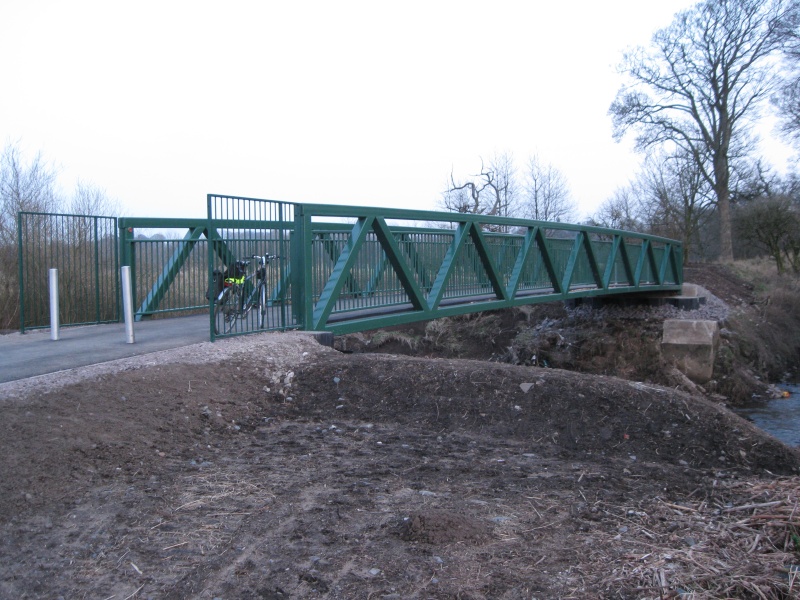
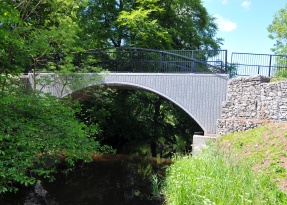 The footbridge over the North Calder Water, at the end of the Monkland Canal at Calderbank, has been replaced by a brand new bridge. The bridge replaces an old timber bridge that was closed after being damaged by fire some years ago. The bridge provides a connection to woodlands on the south bank of the river, and at the top of the steps at the other side of the bridge a track leads through the woods to the A8 bridge at Eurocentral.
 - The Cycling Embassy of Great Britain paid a visit Glasgow and Milngavie on 18 February. An infrastructure safari study tour took place to look at examples of cycle infrastructure, including the Milngavie Road cycle lanes. For a report see Cycling Embassy of Great Britain.
- Sunday 20 November was the date of the Glasgow Cycling Forum’s Glasgow Cycling Infrastructure Tour, organised jointly with Go Bike. This had been organised as a study tour for councillors and roads designers from Glasgow City Council to sample the cycle facilities they have provided and see how well they are performing. The tour consisted of a 22 mile circular tour around the city, by bike, taking in a wide variety of cycling infrastructure. In total, 20 riders took part in the ride which took in routes in the East End, South Side and West End. Details of the route are on the Glasgow Cycling Infrastructure Tour page.
- Glasgow City Council has advised that anyone wanting to suggest small projects for improving cycling, such as new dropped kerbs or signage, should send them in. Email les@glasgow.gov.uk and mark the subject “Cycling Improvements”. Faults should continue to be reported to RALF. Let us know how you get on!
- 75 Sustrans advises us that Airdrie to Bathgate section of NCN 75 has not yet reopened between Plains and Drumgelloch due to a problem with ground conditions and landowner issues. Network Rail and North Lanarkshire Council are currently working on designs for a replacement path adjacent to the main A89 between Towers Road and Plains, including a controlled crossing near Towers Road. It is hoped to complete this towards the end of 2011. Network Rail is also still completing works on the other sections of the route, including erecting signage, millennium mileposts and artworks removed from the original route.
- 75 Sustrans advises us that Gardenside Street in Uddingston, severed by the construction of a new access road at the point where there used to be bollards across the road that let cyclists through, will remain like it is at present for another 3 months. Once works are complete, a short section of shared use footway is to be provided to connect the two parts of Gardenside Street. At present there are apparently temporary ramps somewhere to allow cyclists across the new strip of footway obstructing National Cycle Network Route 75.
- C Go Bike has received quite a lot of adverse comments regarding the Colleges Cycle Route upgrade to Hyndland Road, Highburgh Road and University Avenue in the West End. Additional car parking has been introduced on Highburgh Road with the cycle lanes crammed in to the door zone. Cycle lane widths on University Avenue have been reduced, from the recommended minimum 1.5 metres to around 1 metre. Go Bike will be working through the Glasgow Cycling Forum to get these changes reversed or amended. Please send us any comments on these plans so we can forward them on to the powers that be.In the meantime, members who wish to avoid Highburgh Road could consider using Prince Albert Road (from Hyndland Road at Clarence Drive) and heading down Victoria Crescent Road to Byres Road. In the reverse direction use Dowanside Road and Crown Road North.
- In Edinburgh, The Bike Station has launched the Innertube Map showing the city’s off-road motor-traffic-free cycle paths. In addition to showing paths and access points, the map is backed up with 10 “champions” who ride the routes and report faults. Volunteers will be doing basic maintenance such as vegetation control, and plans are afoot to replace steps at access points with ramps.
- SPT is pushing the back-pedalling option: In December 2010 Strathclyde Passenger Transport gave its cycle locker users notice that the cycle locker hire scheme would be terminated at the end of January 2011, due to the cost of operating the scheme and vandalism. All SPT hired lockers at stations across Strathclyde will be removed. SPT suggests that users transfer to using the open cycle stands at stations, even though these are unguarded and bikes will be vulnerable to the same vandalism as the lockers, except that it will be the bikes’ owners problem instead of SPT’s. Even lockers at stations that have not suffered from vandalism will be removed. This (presumably) does not affect other station locker schemes such as the free South Lanarkshire Council lockers at various stations across South Lanarkshire.
- (C)
 A new ramp has been built connecting the Forth & Clyde Canal Glasgow Branch at Speirs Wharf to the Garscube Landscape Link at Cowcaddens, meaning cyclists can now cycle down from the canal to the cycle routes on the edge of the city centre.Previously cyclists had the choice of dismounting and walking down a large flight of steps, cycling down a grass slope, or joining Craighall Road and cycling through the busy motorway junction. Now the ramp properly connects these important elements in the Glasgow Cycle Network. The ramp compliments the recent work on the Dobbie’s Loan underpass forming the Garscube Landscape Link, and was done in a fraction of the time!Cyclists can now cycle directly from the canal towpath to Woodside via the Garscube Road footbridge and path to Braid Square, to the Colleges Cycle Route (Strathclyde University to Jordanhill) via the path to Cowcaddens, and into Sauchiehall Street precinct via the Cambridge Street cycle lanes, all on signed cycle routes.
 - Go Bike had been promised by Glasgow City Council that cycle lanes removed upon resurfacing in Killermont Street and Royston Road would be reinstated within 28 days. Now more than a year later we are still waiting…
- (75) The new Tradeston-Broomielaw Foot/Cycle Bridge over the River Clyde in Glasgow opened on 14 May 2009, although the promised connecting cycle route from Eglinton Toll, via Salkeld Street and Tradeston Street (see below) has yet to be started. We’ve heard nothing about creating a route to the north, into the city centre. We suggest a contraflow cycle lane on Blythswood Street, between Cadogan Street and Holm Street, allowing cyclists to reach the bridge directly from the Bothwell Street area along reasonably pleasant streets. As a result of the riverside construction work, NCN 75 now runs on the north bank of the river. The route previously ran alongside the Broomielaw roadway.Glasgow City Council has proposed building a City Centre to Govanhill Cycle Route southwards through Tradeston. This route would link the new bridge to the south side of Glasgow. Phase 1 consists of widened and segratated foot/cycleways on Centre Street and Cook Street, with cyclists continuing via Salkeld Street and Devon Place towards Eglinton Toll and Govanhill. Later work would see the route moved to Tradeston Street, once some M74 motorway-building work has been completed, and the route extended to Kinning Park and Pollokshields.
- Connected to the story below, Glasgow City Council is making plans for Glasgow City Centre. Gordon Street is the centre of many of the changes, with pedestrianisation proposed for the section between Renfield Street and West Nile Street, and semi-pedestrianisation for the section immediately west of Renfield Street. Go Bike is concerned about the impact this will have on city centre cycling, since cycling is not allowed in most other pedestrian precincts in Glasgow. Also under threat are the Hope Street contraflow cycle lane between Gordon Street and Waterloo Street, and the Jamaica Street contraflow bus lane between Howard Street and Argyle Street. Further pedestrianisation is proposed for Queen Street north of Ingram Street, for the east side of George Square, and for Trongate west of Candleriggs. Read more on what is proposed in this presentation and the notes for councillors.
- It has been reported in the papers that Glasgow City Council is looking at making West Nile Street in Glasgow City Centre into a cycle route, linking existing cycle routes on the north side of the city centre into provision around Central Station. This is a long-standing Go Bike request finally being taken seriously.
- Go Bike has asked for paths at Port Dundas to be upgraded, forming a link between the Forth & Clyde Canal at Speirs Wharf and the Sighthill Park path network. A shallow set of steps needs to be ramped out, along with improving surfaces on the canal quayside. This would fill a gap in the cycle network by-passing the north of the city centre, complementing improved links to either side.
- Our friends at the Warrington Cycle Campaign have published a book called Crap Cycle Lanes, featuring a selection of poor quality cycle lanes from around the country. Buy it direct from Eye Books.
- (74) Transport Scotland is promoting a major rebuilding of the M74/A725 junction Raith Interchange between Bothwell and Strathclyde Park. This scheme involves putting the A725 in an underpass under the roundabout and providing two cycle routes through the junction. One route connects Bothwell Bridge with Bellshill, while the other is the long-awaited implementation of a cycle link from Bothwell to Strathclyde Park through the junction. However, it appears that this route was an afterthought tacked on at the last minute. It has the following faults:
- Indirect route taking many twists and turns
- The indirectness of the route is compounded by a loop ramp and a double-back ramp at the two footbridges
- Five Toucan Crossings in another loop to get from one side of a road to the other
- Several right-angled corners
- The “main” route through the junction as it is designed is the Bothwell Bridge to Bellshill route, not the Uddingston to Strathclyde Park route which will easily be the more popular of the two
Many of these faults could be avoided by moving the position of one of the proposed footbridges to cross the roundabout slightly further round or taking a different route around the roundabout. Go Bike met Transport Scotland to discuss this further but without success. Sustrans has now decided to reroute NCN 74 away from the Raith Interchange, and instead take it via Blantyre.
- Transport Scotland is also promoting a new motorway between Baillieston and Newhouse. This M8 project will add a six lane motorway alongside the existing A8 dual carriageway, making a 10 lane monster route feeding into Glasgow. This will cause increased traffic on Edinburgh Road, due to the inevitable increased congestion on the existing M8. This is acknowledged by Glasgow City Council’s proposed Baillieston to Daldowie road link, which is planned to displace some of this increase in traffic onto the proposed M74 northern extension.There is to be a cycle route between Baillieston and Eurocentral, but this will be indirect, utilising at times muddy woodland tracks not suitable for commuter cyclists (e.g. going to Strathclyde Business Park), and will not extend as far as Newhouse. It also crosses the busy A752 and A752/A8 sliproad on the flat at Kirkwood. Go Bike has already lodged an objection to this plan.
- See the Weekly List of Planning Applications from Glasgow City Council. Check to see if any planning applications give you cause for concern. If so, and they relate to or impact on cycling, let us know.