
New consultations from the Southside and elsewhere in the city, plus more from North Lanarkshire.
In this Digest there are consultations for a few parts of the Southside and traffic orders for a few City Ways. Also, surveys and events on traffic and town hubs in North Lanarkshire.
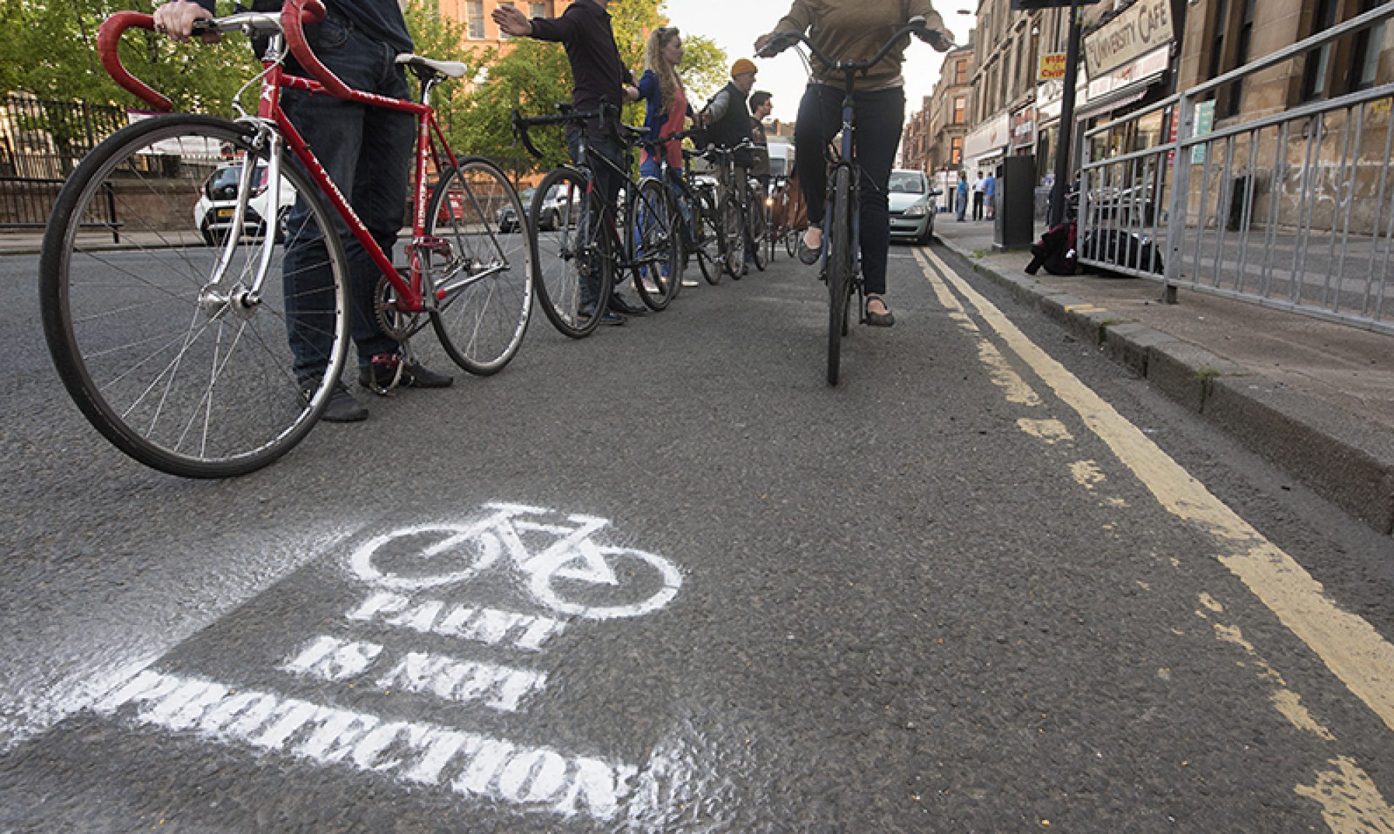
If you’re in the city, see Andy’s three infrastructure routes around Glasgow to take in Spaces for People infrastructure. Part of the Southern route includes the SfP ‘pop-up’ bike lane on Dumbreck Road, which was recently removed “by mistake” but then reinstated.
Andy has also started to inform GoBike about closures and diversions; if you hear of any please do let us know.
Looking further ahead towards spring, and an election, Pedal on Parliament have news about their events in April.
This Digest includes links in the Contents page so you can jump straight to a topic if you want to.
Contents
(new consultations in bold)
Section 1: Current Consultations
- Glasgow City Council – St Andrews Drive (Sustainable Transport Route) Order – closes Sunday 7 March
- North Lanarkshire Council – Town hub community engagement events – events from 8–18 March
- Glasgow City Council – East City Way Phase 1 (London Drive to Daldowie Road) Order – closes Friday 12 March
- Glasgow City Council – London Road/Hamilton Road (30mph Speed Limit) Order – closes Friday 12 March
- Scottish Canals – Stockingfield public meeting – Thursday 18 March
- Glasgow Harbour Ltd – Yorkhill Quay Phase 2 – closes Friday 19 March
- North Lanarkshire Council – Consultations on traffic issues in Calderbank and Chapelhall – closes Sunday 21 March
- Waverley Park Collective – Liveable Streets Waverley Park
- Glasgow Urban Sports – GUSM74 Urban Sports Sculpture Park survey
Section 2: Forthcoming Consultations
None this time
Section 3: Consultation Feedback
Section 1: Current Consultations
(in date order for responses)
1.1: Glasgow City Council – St Andrews Drive (Sustainable Transport Route) Order –Sunday 7 March

Digest 80 covered the St Andrews Drive TRO to extend the South West City Way. The order deals mainly with parking to clear the way for the route.
Further details about the route are still available on the original consultation website (from 2019/2020) including a ‘Storymap’ and links to PDFs of technical plans. The existing SWCW is 2-way (bi-directional), with both lanes on one side of the road. The extension will be too but using ‘cycle lane separators’ (a.k.a. zebras/orcas/armadillos) instead of kerbs.
A GoBike response to the SWCW extension plans was sent to Glasgow City Council in late January 2020. An updated GoBike response supports the order but notes that the other design issues haven’t been addressed.
There’s a consultation period for the TRO with a deadline of 7 March. Since it involves car parking, there are likely to be objections. Supportive emails may help to counter those. See the GCC website at www.glasgow.gov.uk/proposedtro.
1.2: North Lanarkshire Council – Town hub community engagement events

More from North Lanarkshire Council for the second Digest in a row. This consultation isn’t strictly cycling-related but is relevant to the eight places in NLC’s Town Visions plans (Digest 80).
NLC have “ambition to replace every school not replaced or remodelled since 1996, our vision is to make these places for the whole community rather than only the school community. To do this, hubs will be places where education is delivered alongside other council and community services. Hubs will have a form and facilities based on the needs of the local community.”
Those needs should include access by active travel. Schools are also where Bikeability training (formerly Cycling Proficiency) takes place and some already have fleets of bicycles. NLC’s website has further background information on the town hubs.
An email from NLC said: “We are carrying out online engagement with our communities throughout March about potential locations for new town hubs in North Lanarkshire.”
- Kilsyth – Monday 8th March – 6:30pm
- Cumbernauld – Tuesday 9th March – 6:30pm
- Airdrie – Wednesday 10th March – 6:30pm
- Coatbridge – Thursday 11th March – 6:30pm
- Bellshill – Monday 15th March – 6:30pm
- Motherwell – Tuesday 16th March – 6:30pm
- Wishaw – Wednesday 17th March – 6:30pm
- Shotts – Thursday 18th March – 6:30pm
The link for each town goes to an Eventbrite sign-up page to register for the event.
1.3: Glasgow City Council – East City Way Phase 1 (London Drive to Daldowie Road) Order – Friday 12 March
The East City Way traffic order was covered in Digest 80. Phase 1 is currently under construction on London Rd and Hamilton Rd around Mount Vernon train station. The order prepares the ground for it hopefully being finished soon. A new GoBike response about ECW went to Glasgow City Council, referencing our points from our response at the draft stage. Mostly about the switch between 1-way and 2-way cycle lanes and the banned turn. The order will be on GCC’s Proposed TRO webpage for comment until Friday 12 March.
1.4: Glasgow City Council – London Road/Hamilton Road (30mph Speed Limit) Order – Friday 12 March
The London Road/Hamilton Road 30mph Speed Limit was also in Digest 80. It lowers the speed limit all the way along London Rd and Hamilton Rd between Dewar’s distillery and the Dog’s Trust. Again, we sent a new GoBike response supporting the change of speed limit and the order is up for comment until Friday 12 March.
1.5: Scottish Canals – Stockingfield public meeting – Thursday 18 March
Scottish Canals maintain and develop canals, towpaths and bridges, including the major works at the Stockingfield junction on the Forth & Clyde canal. This is the canal t-junction without a bridge, where you had to cross by going down through a narrow road tunnel on Lochburn Rd with no pavements or bike path. The plans for a large 3-span canal bridge were approved in March 2020 and works started in autumn. Parts of the towpath will be closed and won’t re-open until later in 2022. Further information about the project is on the Stockingfield page on the Scottish Canals website. If you have questions about issues, like diversions or the new bike-only signals on Lochburn Rd, Scottish Canals are having an online meeting about the project on Thursday 18 March.
1.6: Glasgow Harbour Ltd – Yorkhill Quay Phase 2 – closes Friday 19 March

This development first appeared on our radar in Digest 73, Item 1.1. It had a brief consultation which swiftly disappeared from the company’s website (as we noted in Digest 74, Item 1.3). That was to do with a pre-application about the masterplan for the site. Apparently, “a Proposal of Application Notice (PoAN) associated with the development was submitted to Glasgow City Council on 20th November 2020”. So, this consultation about the eastern side of the site is part of the 12-week pre-application period before plans go in.
The developer’s Yorkhill Quay website has new visualisations (which look very plastic) and reworked PDF plans. It’s not clear from the plans what will happen to the current path behind the site, between the Riverside Museum and the distillery. Nor how wide the new riverfront path will be (but it seems to have street furniture and trees splitting it up).

The Next Steps and Feedback page has a webform you can use to send comments. Or you can email: yorkhillquay@iceniprojects.com by Friday 19 March.
1.7: North Lanarkshire Council – Consultations on traffic issues in Calderbank and Chapelhall – Sunday 21 March

Back in North Lanarkshire, the council is consulting about traffic in the villages of Calderbank and Chapelhall, between Airdrie and the M8. Their email says:
“In response to road safety concerns raised by local residents, the council undertook a series of detailed surveys to assess traffic conditions through both villages. Information from these surveys will be included in the reports.
The public consultation, which will run until 21 March, will give both communities the opportunity to provide feedback on a range of potential road safety improvements.
The reports and online consultation are available from 24 February on our website at www.northlanarkshire.gov.uk/traffic-studies.”
The Chapelhall Traffic Study, in the ‘Potential Improvements’ section, suggests speed tables and mini-roundabouts. The Calderbank Traffic Study proposes mini-roundabouts too but also includes a new crossing on Main St. Each study has a survey link at the end. If you know the areas you have until Sunday 21 March to respond.
1.8: Waverley Park Collective – Liveable Streets Waverley Park

Waverley Park is an area of Shawlands in the Southside of Glasgow (where the streets are named after characters in Walter Scott novels). The Waverley Park Collective are a grassroots group of residents who’ve previously organised community events for children as well as things like cycling training. They’ve recently won funding to plan changes to local streets and set up the Liveable Streets Waverley Park consultation. If you know the area, you can add a pin to the map. No obvious closing date for this one (seems to be open-ended).
1.9: Glasgow Urban Sports – GUSM74 Urban Sports Sculpture Park

This item is about a different kind of cycling to your average GoBike ride! The Glasgow Urban Sports group want to bring land under the M74 extension into productive use as a park for ‘urban sports’ – BMX, skateboarding, inline skating, parkour, etc. The area is between the back of West St Subway station and Eglinton St (a few blocks from Batley’s cash & carry warehouse). The idea for the project originally came up around 2014 (as a legacy of the Commonwealth Games).
Recently, GUS have come up with a new survey to try and demonstrate support for the project. It’s mainly aimed at skaters, or their families, to find out how often they/their relatives might use the park, etc. If you’re not likely to be down there yourself grinding any rails then feel free to share it with friends or family who might. No obvious closing date.
Section 2: Forthcoming Consultations
None this time.
Section 3: Consultation Feedback
3.1: Urban Roots – Malls Mire Newsletter February 2021
Malls Mire was first covered (under its current name) in Digest 74, Item 3.4. The latest February issue of the Malls Mire newsletter reached us this week. It has a few updates about progress and related projects like Polmadie Plots Community Garden.
3.2: Sustrans – Glasgow Cycle Counters (revisited)
In Digest 79, Item 3.3 we bade farewell to the public cycle counter near Saltmarket in Glasgow Green as it was switched off. We were assured that “two replacement cycle counters were installed in the following locations: NCN75 at St. Andrew’s Suspension Bridge and NCN75 at Cuningar Loop Footbridge”. Turns out the new counters aren’t like-for-like replacements…

The new counter feeds back figures to Sustrans/the council only. While that is fair enough for collecting data, it’s not so good for campaigning. The public counter used to prove how many people cycled past, which could be useful to point out to doubters of cycling/active travel. It would be a shame if Sustrans had moved away from public counters altogether. When will we see the Saltmarket counter’s LED like again…?