Infrastructure
‘Provisional COVID-19 infrastructure induces large, rapid increases in cycling‘ (February 2021) Sebastian Kraus, Nicolas Koch; PNAS
Study using “space for people” like interventions for measuring how infrastructure increases cycling volumes.
‘The Impact of Introducing Low Traffic Neighbourhoods on Road Traffic Injuries‘ (January 2021) Anthony A Laverty, Rachel Aldred, Anna Goodman; Transport Findings
Study examining the impact on road traffic injuries of introducing low traffic neighbourhoods in Waltham Forest, London. Findings:
* a three-fold decline in number of injuries inside low traffic neighbourhoods after implementation, relative to the rest of Waltham Forest and the rest of Outer London.
* walking, cycling, and driving all became approximately 3-4 times safer per trip.
* no evidence that injury numbers changed on boundary roads.
* low traffic neighbourhoods reduce injury risks across all modes inside the neighbourhood, without negative impacts at the boundary.
‘Pave The Way. The impact of Low Traffic Neighbourhoods (LTNs) on disabled peopled, and the future of accessible Active Travel‘ (January 2021) Transport for All
Report examining the positive and negative impacts that Low Traffic Neighbourhoods have on people with disabilities, including a series of recommendations on measures and solutions.
‘Cycling Injury Risk in London: Impacts of Road Characteristics and Infrastructure‘(December 2020) Thomas Adams, Rachel Aldred
Research showing that painted lanes can make cycling more dangerous (increases injury odds by 34%), while kerb separated or stepped track cycle lanes can reduce risk of injury by 40-65%.
‘Low Traffic Neighbourhoods‘ (October 2020) SPICE
Post from the Scottish Parliament Information Centre answering some of the questions raised about Low Traffic Neighbourhoods using research findings from studies into existing LTNs. Demonstrates among other things that LTN’s can:
* reduce car use by those living within scheme boundaries.
* reduce general traffic levels.
* increase levels of walking and cycling.
* help reduce local air pollution.
‘Streets for Everyone‘ (2020) Sustrans
A series of short videos in which local businesses and residents across the UK explain why changes that make walking, wheeling and cycling safer for everyone, matter to them.
‘Street Design Standards – Current and Withdrawn Practice‘ (2020) Institution of Civil Engineers
This summary compares current best practice street design guidance with withdrawn
old-era street design guidance and standards, that should not be used.
‘Response to Town Centre Expert Review Group’s call for evidence
on town centre revitalisation’ (August 2020) Glasgow Centre for Population Health
There are a range of transport-related changes that if implemented together, or in some sort of complementary combination, could have a favourable impact on levels of walking, cycling and wheeling in our towns and cities and related positive impacts on carbon emissions, air pollution levels and local economies.
These include:
* reducing road speeds to 20mph or lower and restricting through traffic in order to protect
the most vulnerable road users and to make streets feel safer
* introducing bus gates to encourage public transport and reduce through traffic by private
cars
* reducing private parking and enhanced use of pavements by retailers, cafés and
restaurants without creating undue street clutter
* integrated walking and cycling routes to create a safe and accessible active travel
network
* supporting bike share and car share schemes, taking care to make sure these are made
available across all communities and not in a way that skews availability to favour more
affluent areas
* integrating transport options across all forms of sustainable transport e.g. tickets that can
be used on a bus, train or subway, or to hire a bike.
‘Private vehicles are stealing public cities: land-use analysis across
Glasgow and Dundee, Scotland‘ (July 2020) Marli de Jongh, SAGES
Study showing that a third of city space is overwhelmingly dedicated to the car: roads, car parks and on-street parking cumulatively account for the highest proportion of space at each site. Across each case study, space dedicated to cars ranged between 34.5% and 41% (Fig. 1). Green spaces, public transport and cycling infrastructure are extremely lacking and appear to be of relatively low priority.

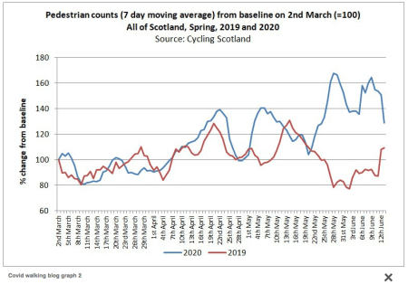
‘Walking during the lockdown in Scotland‘ (July 2020) Glasgow Centre for Population Health
Research suggests walking for leisure increased during the lockdown phase and remained high during Phase 1.

‘Making the shift to sustainable transport in Scotland‘ (June 2020) Davis, A & Whyte, B.
Transport sector decarbonisation is a Scottish Government policy aim. Recent legislation and funding announcements are beginning a shift away from support for habitual car use.
Sustainable transport is augmented by co-benefits of active travel itself through improvements in air quality, safety, and benefits across other sectors. At a workshop, attendees identified the need for further actions including closing down the roads programme and shifting funding to sustainable transport, reducing the need for travel, and a major shift to active travel for journeys under 3 km. Such actions are reflected on in the context of the current coronavirus.
‘Cycling through a pandemic’ (June 2020) Glasgow Centre for Population Health
How and where cycling rates have changed during lockdown. “A quarter of people said that having more dedicated cycle paths would be the most likely change to encourage them to cycle once lockdown is lifted.”

‘Active Recovery: Locking-in the active travel benefits’ (May 2020) YouGov commissioned by Transform Scotland
Poll showing that:
4 in 5 city residents want cars to give way to bikes, buses and walking to tackle urban air pollution
77% of respondents agreed that ‘More public space should be reserved for pedestrians’ (6% disagreed)
65% of respondents agreed that ‘More public space in your nearest town/ city should be reserved for cycling’ (18% disagreed)
‘Evaporating traffic? Impact of low-traffic neighbourhoods on main roads‘ (2019) Emma Griffin, vice-chair, London Living Streets
Experience reveals that predictions of traffic problems caused by low-traffic neighbourhoods almost always fail to materialise, and that significant reductions in overall traffic levels across an area can happen as a result of people making a wide range of behavioural responses to the new traffic configurations.
‘How much space do drivers provide when passing cyclists? Understanding the impact of motor vehicle and infrastructure characteristics on passing distance‘ (2019) Accident Analysis and Prevention Journal
Highlights:
One in every 17 passing events was a close (<100 cm) passing event.
We noted links between motor vehicle types and infrastructure characteristics, and passing distance.
Specifically, on-road bicycle lanes and parked cars reduced passing distance.
These data can be used to inform the selection and design of cycling-related infrastructure.
‘Essential Evidence 4 Scotland No 4 – Critical success conditions of collaborative methods in transport planning’ (2019) Transport Research Institute
In the development and delivery of transport planning projects, dedicated management of the multi-actor network, a high diversity of actors, as well as an extensive use of knowledge integration methods in combination with a high network density are critical success conditions.
‘Essential Evidence 4 Scotland No 3 -Do just the physically active do more active travel when environments improve or are changes shared across the population’ (2018) Transport Research Institute
Environmental improvement encourage the less active to take up walking for transport, as well as encouraging those who are already active to walk more.
‘Transport for New Homes‘ (2018) Foundations for Integrated Transport
We have seen some good examples of new homes where residents can use a combination of walking, cycling or public transport to go about their daily lives. However, most new developments we have seen, particularly those built on large greenfield sites on the edges of towns, are designed for travel by cars. They have plentiful car parking, but limited or no access to public transport, limited facilities and services, and a lack of safe pedestrian or cycling routes to town centres or the surrounding area. The new ‘urban extensions’ and ‘garden villages’ by their very location away from large conurbations promote car-based living. This is a major issue of public policy.
‘Cities Alive: Towards a walking world‘ (2016) ARUP
Report highlighting the significant social, economic, environmental and political benefits of walking. “Informed by specialist insight and multidisciplinary expertise from across our global offices, we highlight 50 benefits of walking explored through 16 distinct indicative themes, and list 40 actions that city leaders can consider to inform walking policy, strategy and design.” One study found that people in walkable neighborhoods had 80% more “social capital” than those living in car-dependant areas.

‘The Role of Cycling and Walking in Reducing Congestion‘ (2016) Flow Project
This portfolio of measures describes the actual effects of different types of measures
on congestion by presenting case studies of successfully implemented urban measures supportive of walking and cycling. The measures described have helped reduce congestion or at least have increased walking and/or cycling levels without increasing
congestion.

‘Off-street Trials of a Dutch Style Roundabout ‘ (2015) Transport Research Laboratory

‘Understanding road usage patterns in urban areas‘ (2012) Scientific Reports
“In this paper, we combine the most complete record of daily mobility, based on large-scale mobile phone data, with detailed Geographic Information System (GIS) data, uncovering previously hidden patterns in urban road usage. We find that the major usage of each road segment can be traced to its own – surprisingly few – driver sources. Based on this finding we propose a network of road usage by defining a bipartite network framework, demonstrating that in contrast to traditional approaches, which define road importance solely by topological measures, the role of a road segment depends on both: its betweeness and its degree in the road usage network.”
‘Glasgow Local Development Plan: Baseline Transport/Land Use Modelling 2011-14‘ (2011) Strathclyde Partnership for Transport
‘To Curb Driving, Cities Cut Down on Car Parking’ (2011) National Geographic
How cities around the world are recognizing that managing parking is an effective, if indirect, means of addressing concerns about energy and traffic congestion—indeed, climate change.
‘Why Bicyclists Hate Stop Signs‘ (2001) Curry, M & Fajans, J
On a street with a stop sign every 300 feet, calculations predict that the average speed of a 150-pound rider putting out 100 watts of power will diminish by about forty percent.
‘Making the most out of scarce road space’ Cycling Embassy of Great Britain
‘A short history of traffic engineering’ Copenhagenize
‘Change the question’ Copenhagenize
‘Capacity’ The Cycling Embassy of Great Britain
‘Appropriate Transport’ Space for People Byres Road
‘Traffic Psychology and Behaviour’ Science Direct
http://cidadanialxmob.tripod.com/shoppersandhowtheytravel.pdf
This is a Sustrans document demonstrating that cars are not necessary outside shops and businesses and that active travel can generate more business.

