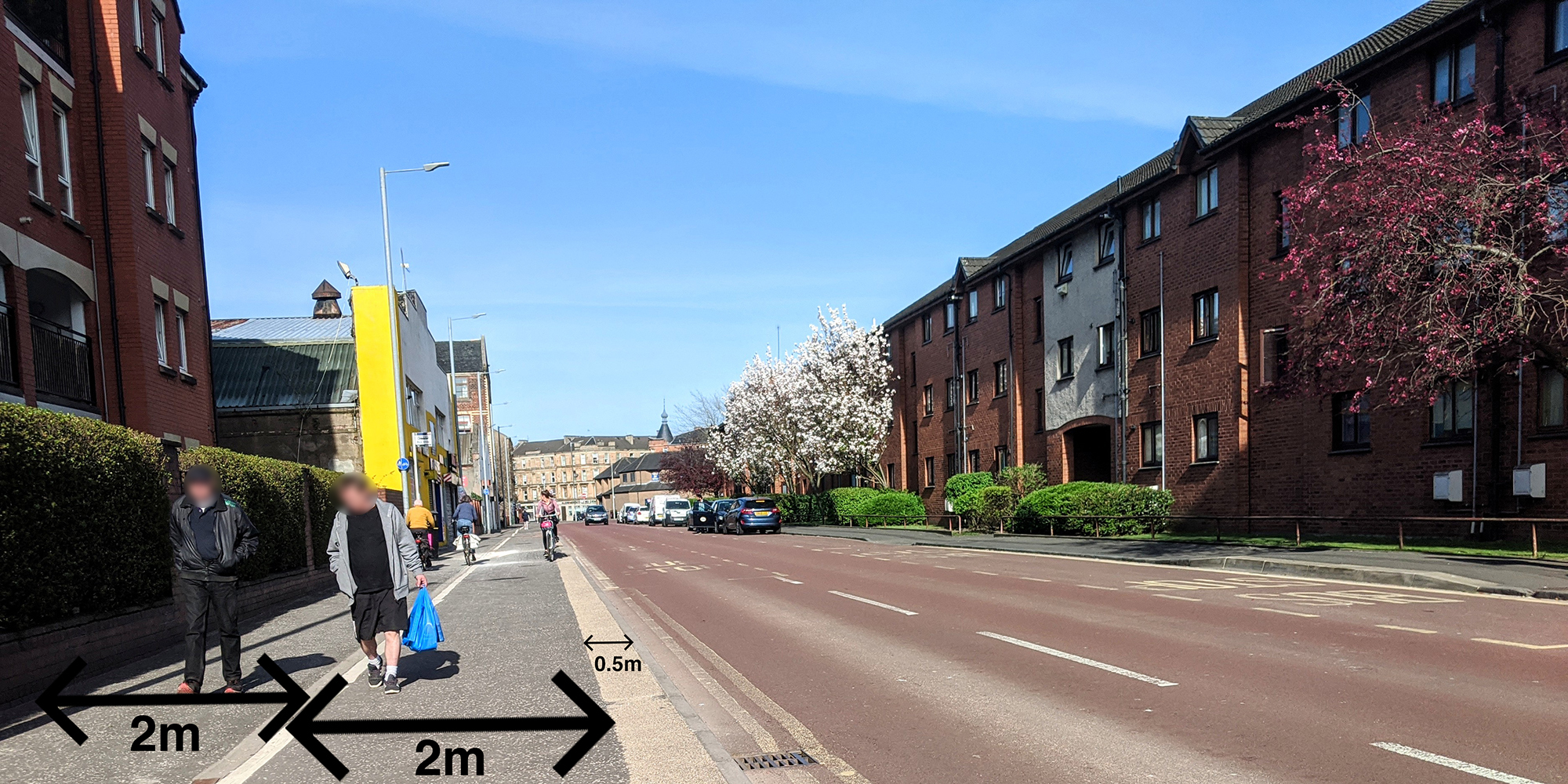
After the GoBike AGM (29 November) two rides to look at infrastructure, and more in Glasgow

After our AGM and Public Meeting tomorrow, 7:30pm at the Admiral Bar, with what is very likely to be a lively discussion about cycle infrastructure in Glasgow, why not join one or both of our forthcoming rides to look in more detail at the city?  Both rides devised and led by Andy Preece, with further details on our Rides page. Continue reading “After the GoBike AGM (29 November) two rides to look at infrastructure, and more in Glasgow”

Councillor Tour 10, Govan, Ward 5 with Councillor Allan Young (Green Party), 11 November 2017

On Saturday 11th November 2017, GoBike members Bob Downie and Andy Winter, and Rumina Kakati (who leads rides enjoyed by new, nervous and lapsed cyclists) met with Allan Young, the Green councillor for Govan ward, to go on a tour of some of the cycle facilities in the ward. Committee member Brenda Lillicrap organised the ride but was prevented from doing all but the start of the tour by a puncture.  We were delighted that Allan was available to come out with us and hope that the other three ward councillors will be able to come for a similar tour in future. The invitation remains open . Our route took us out and back from Cessnock subway station, past Bell’s Bridge, the Science Centre, Queen Elizabeth University Hospital and Govan centre, all the while critiquing the cycle facilities we saw and used, good and bad.

Our start was in Walmer Crescent, a short one-way street with slow traffic, no junctions, and a sharp corner at both ends – ideal for the council’s declared default of permitting contraflow cycling on one-way streets. Not yet though.

Picture 1, shown above: Start – Govan Ward 5 Tour 11/11/17, Rumina Kakati, Allan Young, Andy Winter and Bob Downie at Cessnock Station

Picture 2Map Route taken on Govan Ward 5 tour 11/11/17. Numbered points refer to photograph locations below

Our route initially took us north on the signed Cycle Route 7 along Cessnock Street, Brand Street – now with perpendicular parking for the new flats along the south side, a potential hazard for cyclists on this well-used route – and Govan Road. We able to see the ‘improvements’ being made connected with Fastlink. We wondered about the value of spending money on a grade-separated cycleway alongside a road where the only permitted traffic is buses and taxis – and there aren’t any bus routes. There are much stronger candidate areas for cycle infrastructure spending even when the funding is ring-fenced for work connected with Fastlink.

Our first major hurdle was where Govan Road joins Pacific Drive. At these traffic lights, cyclists are invited to behave like pedestrians and cross Pacific Drive to cycle westward on the north-side pavement. To cross, cyclists must wait for 3 individual sets of pedestrian controlled lights, the first to cross the two lanes of the Fastlink bus corridor (not available for cycle use), followed by lights for each lane of ordinary traffic. The presence of extensive pedestrian barriers makes crossing by more than 2-3 bikes at a time very difficult. The experienced cyclists will almost certainly ignore the invitation to use this crossing and travel westward on the road. Those new to cycling (or with tandems, trailers or cargo bikes) are discouraged by tight turns made more difficult by poles, railings and control boxes, especially when there are pedestrians or other cyclists to consider.

While manoeuvring the crossing we agreed that plans to designate the footway on the south side for shared use (right through the bus shelter, and next to the sparsely used Fastlink carriageway) were a frustratingly marginal improvement, and we wondered why no effort had been made to route cyclists behind the Village Hotel to get toward’s Bells Bridge. There is already a crossing across Pacific Drive opposite the Bell’s Bridge path, albeit one offset from the desire line and with yet more barrier/pole/box obstacles.

Picture 3CrossToPavement We were invited to behave as pedestrians and use the pavement on the north side of Pacific Drive (point 1 on map)

It was generally agreed that the new path from Pacific Drive to Bell’s Bridge then continuing along the river in front of the BBC and the Science Centre was excellent. We wished it were possible for the riverside path to extend eastwards under the Clyde Arc Bridge. Back at Govan Road we continued westward and on to Golspie Street, which was re-engineered to accommodate the Fastlink carriageway. This gives it the appearance of a fast dual-carriageway, by-pass type of road, with its absence of active frontages and sweeping turns at the junctions. With the two directions of normal traffic using the single non-Fastlink carriageway it feels like a hostile piece of road for cyclists. This section is difficult to avoid for east-west travel because of the barrier of the lines into the subway depot. The layout of the both junctions on this stretch encourages drivers to make fast left turns, with the potential for left-hooking cyclists. The extensive pedestrian barriers at the junction with Harmony Row hem cyclists in in a manner that is worrying. There is nowhere for cyclists to escape if cars come too near.

Picture 4Barriers Extensive barriers at the junction of Golspie Street and Harmony Row (point 2 on map)

A newish, good quality pedestrian-cycle route took us the 200m from Golspie Street to Langlands Road. This was free of motor traffic and wide enough for cyclists and pedestrian to easily pass in both directions. A useful improvement would be a dropped kerb at the eastern end to allow easy access for west-bound cyclists without having to mingle with pedestrians at the pelican crossing.

Picture 5SharedPath Using the Golspie Street to Langlands Road cycle/pedestrian route (point 3 on map)

On Langlands Road significant sections of the advisory cycle lanes, only denoted by painted lines, were blocked by parked cars on both sides of the road. We understand these painted lanes form part of the ‘active travel access’ for the newly enlarged hospital. Allowing parking in cycle lanes shows that cyclists lack any real status on Glasgow’s roads. Cycle users deserve better.

Picture 6CarsInBikeLane Cars parked in the Langlands Road cycle lane (point 4 on map)

We carried on along Langlands Road to the underpass beneath the A739, the busy dual carriageway leading to the Clyde Tunnel. This underpass gives cycle access to the Queen Elizabeth University Hospital, but the large amount of graffiti and general feel of dilapidation gives it an edgy feel. This is not a facility most people would like to use at night.

Picture 7Graffiti Pedestrian/cycle underpass beneath the A739 to the Queen Elizabeth University Hospital. A highly graffitied and unwelcoming place (point 5 on map)

The feeling of dilapidation continued on the west side of the A739 where the first entrance to the hospital had no dropped kerb as well as being very rough, and needing another tight turn to negotiate the bollards in the underpass entrance.

Picture 8HospEntrance Off-putting entrance to the QEUH. Note the lack of dropped kerb (point 6 on map)

We continued north beside the A739 on an excellent shared pedestrian/cycle path which continued along Moss Road. At the junction with Peninver Drive a new pedestrian/cycle crossing has been installed but the timing of the lights was so slow (about 3 minutes) that no one was inclined to wait and we all took the chance to cross when the traffic appeared clear. The timing of these lights needs to be reviewed.

Picture 9LongWait Very slow timing of the lights allowing cycle crossing from Moss Road to Peninver Drive (point 7 on map)

Onward to Govan Road where we noted that parking was allowed by the shops near the junction with Holmfauldhead Place. We were told that this parking can at times cause significant congestion leading to cyclists being squeezed on the road, with drivers overtaking without allowing sufficient space.

Picture 95ParkingSqueeze Govan Road near the junction with Holmfauldhead Place. A busy road restricted by allowing on-street parking. Cyclists get squeezed here (point 8 on map)

A major problem in this area is the difficulty that south-going cyclists have turning west along Govan Road when they exit the Clyde Cycle Tunnel. To cross Govan Road “by the book” is so slow and complex that few cyclists comply and simply cross Govan Road when and where they can. The lack of a simple and safe crossing is simply unacceptable.

Our tour concluded with a ride through the centre of Govan and discussion as to how a dedicated cycle route through the main street of Govan Road could be a significant feature as part of the area regeneration.

Overall we were underwhelmed by the cycle facilities that we saw and used in Govan. Short sections were excellent but on the whole we felt that most were let down by poor design and poor implementation. The biggest issues are the lack of interconnectivity between adequate facilities and the method the planners use to take cyclists across main roads by requiring cyclists to behave like pedestrians and use complex, slow, barriered crossings. These are tricky for inexperienced cyclists to manoeuvre through, and experienced cyclists are likely to ignore the lights and cross as and when they see a gap in the traffic. The perennial problem of cars parking in non-segregated cycle lanes remains an issue in Govan as almost everywhere else in the UK.

We hope that Councillor Allan Young will be able to use the information gained in this tour to inform him in his work as a councillor and as ever, GoBike are here to help should he (or any of the other three Govan councillors) have any further questions.

We have one more tour planned for Friday 01 December with Councillors Cullen and Cunningham around Ward 13, Garscadden/Scotstounhill.  Then, unless we can choose daylight during the winter, we’ll be hoping to resume in the spring – if councillors are minded to join us!

Battlefield Public Realm consultation – goes live today, 23 November, public event 30 November


Glasgow City Council is launching public consultation about the junction of Battlefield Road, Grange Road , Prospecthill Road and Sinclair Drive.  Anyone who has tried to negotiate this junction on a bike or on foot will know that it’s tricky.  We are told that the on-line consultation will go live today, 23 November at: www.glasgow.gov.uk/battlefield and it is now live.  However, it may be best to wait, if you can until you have been to the public consultation event – details below – before submitting comments:

The consultation will, according to the website, allow acceptable designs to progress in order to achieve match funding from SPT in 2018/19.

A public drop in session will be held on:

Thursday 30th November 2017

3pm-7pm

Langside Library

2 Sinclair Drive, Glasgow, G42 9QE

Online survey/comments closing date: 22/12/2017

Just one week to go: GoBike AGM and Public Meeting, 29 November 2017

Yes, just 7 sleeps to go until our 2017 AGM and Public Meeting with Anna Richardson, Glasgow City Council’s Convenor for Sustainability and Carbon Reduction, on Wednesday 29 November.

The venue is the downstairs room of the Admiral Bar on the Waterloo Street section of the West City Way with cycle parking nearby and a NextBike station too. Continue reading “Just one week to go: GoBike AGM and Public Meeting, 29 November 2017”

Knightswood Park BMX track – Cycle Route access, part 1, Segregated


Glasgow City Council are planning a part segregated and part shared footway cycle route access to Knightswood Park, to be built in time for the 2018 European BMX Championships, for which the park will be a venue.

There was public consultation in August but we were not formally told of this although some of our members went along.  The Traffic Regulation Order that has been issued is sparse on information but after asking questions of the Council Officer who is dealing with the scheme we were sent drawings earlier this week.  These have helped to formulate our response: GoBike Yoker to Knightwood Sustainable Transport Corridor 1 171117  This is only to the segregated cycleway part of the scheme.  The more contentious part is the shared footway element and we’ll get our response to that out well before the closing date next month.

Consultation on this segregated element closes on 19 November and the TRO documents are here: YokerToKnightswood-NoticeOfProposals-230x114mm-RTO TRO no waiting no loading cycle track 1 of 3 TRO corner protection 3 of 3 TRO corner protection 2 of 3 TRO information Report

In summary, we support the segregated cycleway but have concerns about junction treatment, management of parking, the cycleway width behind floating bus stops, the robustness of the orcas without bollard reinforcement and the connectivity of the scheme.

Queen Margaret Drive, Glasgow, Consultation event on revamp, 22 November 2017


We have been forwarded information about a forthcoming consultation event by Glasgow City Council arising from proposals by the Queen Margaret Drive community to improve their street:

_________________________________________________________________________________

“Subject: Queen Margaret Drive Community Engagement

 MESSAGE SENT ON BEHALF OF CHRISTINE FRANCIS, DIVISIONAL MANAGER, TECHNICAL SERVICES, LAND AND ENVIRONMENTAL SERVICES.

Following on from consultations organised by the local community of Queen Margaret Drive, Glasgow City Council (GCC) are taking forward a project to enhance walking and cycling provision in the area. 

GCC will be holding a public engagement event with a supplementary online survey to gather comments.  The outcome is to achieve a design that can be constructed in partnership with Sustrans and the local community. 

We are proposing a number of changes to improve the environment for cyclists, pedestrians, local residents and businesses. New designs could see the implementation of:

•        Improved paths

•        Improved pedestrian crossings

•        Reallocation of road space.

•        cycle lanes

The consultation will allow acceptable designs to progress in order to achieve match funding from Sustrans in 2018/19.

A public drop in session will be held on:

Wednesday 22nd November

3pm-7pm

76 Kelbourne Scout Hall

Kelbourne Street

G20 8PR

Information and an online survey will be available and will be live from 15th November for a period of 4 weeks. The survey will be available at: www.glasgow.gov.uk/qmd.

Consultation posters will be erected in public premises and a leaflet drop will take place in Queen Margaret Drive. A copy of the distributed leaflet is attached for your information. This will provide the public the opportunity for residents and businesses to provide comments on the proposals that might assist with the detailed layout.

The closing date for consultation will be the 15th December.

I trust this is of assistance; however, should you require any further information, please contactSustainabletransport@glasgow.gov.uk “

________________________________________________________________________________

A local GoBike member says

“It articulates with the Byres Road refurbishment.

In addition, we are to get a new primary school at the top of QMD at the junction with Maryhill Road, where there is a blaes football pitch. There is an overgrown footpath around the south and east of the site, which will be retained and restored. This leads directly from QMD to a crossing on Maryhill Road directly opposite an access point to the canal (There is a student village on the other side and Scottish Canals recently installed cycle racks beside the footbridge.)

So, the QMD development will give us a continuous link from the canal, down QMD and Byres Road, across Dumbarton Road at Partick Cross and on to the Riverside Museum and the new footbridge to Govan.

It also connects with the Kelvin Walkway (NCN 756).

So, it meets with our objectives of having a continuous network following routes where cyclists want to go.”

The city council have produced one of their cards to advertise the event: QMD active travel Postcard LR

Please do get along to this event if you can and contribute to making Queen Margaret Drive a place for people not cars.

Glasgow West School Run Summit – a success


Last week we told you about the forthcoming West Glasgow School Run Summit, hosted by Dumbarton Road Corridor Environment Trust, that took place on 14 November.  We are pleased to hear that the event was a success, see the press release that has been issued: 20171116_DRCET_SchoolRunSummit_PressRelease  So let’s hope that we soon see more school runs by car becoming school runs by foot or bike!


A positive outcome of the event is that Councillor Michael Cullen, for Garscadden/Scotstounhill, SNP, who attended the event, has now been in touch to say that he would like to cycle with us round his ward.  We’ll be progressing that and, hopefully, we might get some of his ward colleagues along too.

2 weeks to go – GoBike AGM and Public Meeting with Anna Richardson, 29 November


Yes, just 2 weeks to go until our AGM, followed by discussion with Anna Richardson, Glasgow City Council’s Convenor for Sustainability and Carbon Reduction – this includes all things cycling, walking and roads.

In the AGM we hope to approve our new constitution and elect people to be on our main committee and our sub-committee action groups to take projects and campaigns forward.  We are very excited about the prospect of 2 Co-Convenors to take campaigning for good cycle infrastructure in Glasgow and Strathclyde forward, an improved focus on consultations and we are looking for people to help with marketing the campaign and increasing membership.  Do please volunteer to join in!

Anna Richardson will be talking about the challenges of her role and answering your questions about how we take the city forward to be a place for people.

The details are on our flyer: GB! AGM2017

Venue: The Admiral Bar, 72a Waterloo Street, Glasgow, G2 7DA, with cycle parking and a NextBike station nearby.

Date: Wednesday 29 November 2017

Doors open: 7pm (the bar upstairs will be open before then for both food and drink)

AGM: 7:30pm

Anna Richardson: 8pm

Please do come along, bring a friend and share this information.


Candleriggs Glasgow, hotel to be built and new contraflow cycle lane!


The old Goldberg site on Candleriggs, from Wilson Street down to the Trongate is being redeveloped and road access is being changed to facilitate access to the hotel being built there.  The good news for active travel is that there will be no through motor access from Bell Street to Wilson Street (the junction at the foot of the photo) and there will be a contraflow cycle lane on the south part of Candleriggs, to allow two-way cycling here.

GoBike’s letter of support, but with some related questions, is here: GoBike Candleriggs Traffic Mgt support 111117 and the City Council’s explanation of what is proposed is here: CCTRO Variation20 Candleriggs Report Feb2017 with this plan: P5056_06_02B_Candleriggs TRO

Full details of Glasgow City Council’s proposals may be seen here

Comments don’t close until 08 December, so there is plenty of time to get your views in!

Buy your shares in Speed Cushions now – and prepare for a bumpy ride!

Glasgow City Council are currently consulting on 3 proposals, one to install 8 asphalt road humps (similar to the photo) and two to install a total of 251 speed cushions, in 3 separate areas of Glasgow where a 20mph speed limit is being introduced.  This is despite Councillor Anna Richardson, Convenor of Sustainability and Carbon Reduction, saying, infront of about 200 people at today’s Cycling Scotland Conference in Glasgow, that her aim is to go for a city-wide 20mph speed limit with a justification being made for retaining limits of 30mph.  We have studied the proposals and have submitted objections.  In each case we have objected on the grounds that there has been no consideration of cycle traffic, that the money would be better spent on a city-wide scheme and have suggested that there should be liaison with Police Scotland to educate motorists who risk injury and death by exceeding the speed limit. The 3 proposals are:

Kempsthorn Road, Beltrees Road and Beltrees Crescent in Pollok, where 8 asphalt road humps are proposed.  We have suggested in addition that if the area is being used as a rat run that the through route should be blocked to motor traffic, which would have the added benefit of encouraging active travel.  A copy of the initial e-mail and the plan from GCC, plus the GoBike letter of objection are below:

Kempsthorn Road Traffic Calming email sent 11October 2017 Kempsthorn Road Traffic Calming GoBike Kempsthorn Road traffic calming objection 311017

Kingsland Drive and Thurston Road in Hillington/Cardonald, where 7 sets of cushions, ie 14 cushions in total, are proposed.  We have suggested that cycle lanes should be installed using armadillos or similar on each side of these roads, which, by narrowing the roadway, would reduce traffic speeds and also encourage active travel.  We do not know whether any analysis of the speeding vehicles has been carried out, but should it be that the roads are being used as a rat run then, either as an alternative, or an addition to the cycle lanes, consideration should be given to stopping off the through route to motor traffic.  A copy of the initial e-mail and the plan from GCC, plus the GoBike letter of objection are below:

Kingsland Drive email sent 09October 2017 Kingsland Drive traffic calming GoBike Kingsland Drive and Thurston Road traffic calming objection 311017

Consultation on both these schemes closes tomorrow 01 November, so if you wish to also submit an objection – or even a letter of support, we haven’t left you much time – sorry.

The third scheme, for which consultation closes on Friday 03 November is:

The Citywide 6A Traffic Calming Scheme, which, we are very pleased to see, covers a much bigger area than any proposed to date by Glasgow City Council, see this photograph of the plan:

This covers the very area where, with no consultation of which we are aware, shared footways are being installed under the guise of Fastlink Cycle Upgrades – see our previous post of 25 October.  While it is good to see a bigger area proposed for 20mph we are not pleased to see that it is proposed to install 237, yes 237, speed cushions in this one area alone.  At this rate, how many will be required for the whole city?  A truly citywide scheme is required where it is clear that, unless otherwise signed, speed limit is 20mph, and is managed as such.  We have suggested that cycle lanes using armadillos, or similar, be installed on either side of each road here to reduce motor traffic speeds and encourage active travel.  GCC’s e-mail to us and our letter of objection are here: Citywide 6A email sent 13 October 2017 GoBike Citywide 6A traffic calming scheme objection 311017