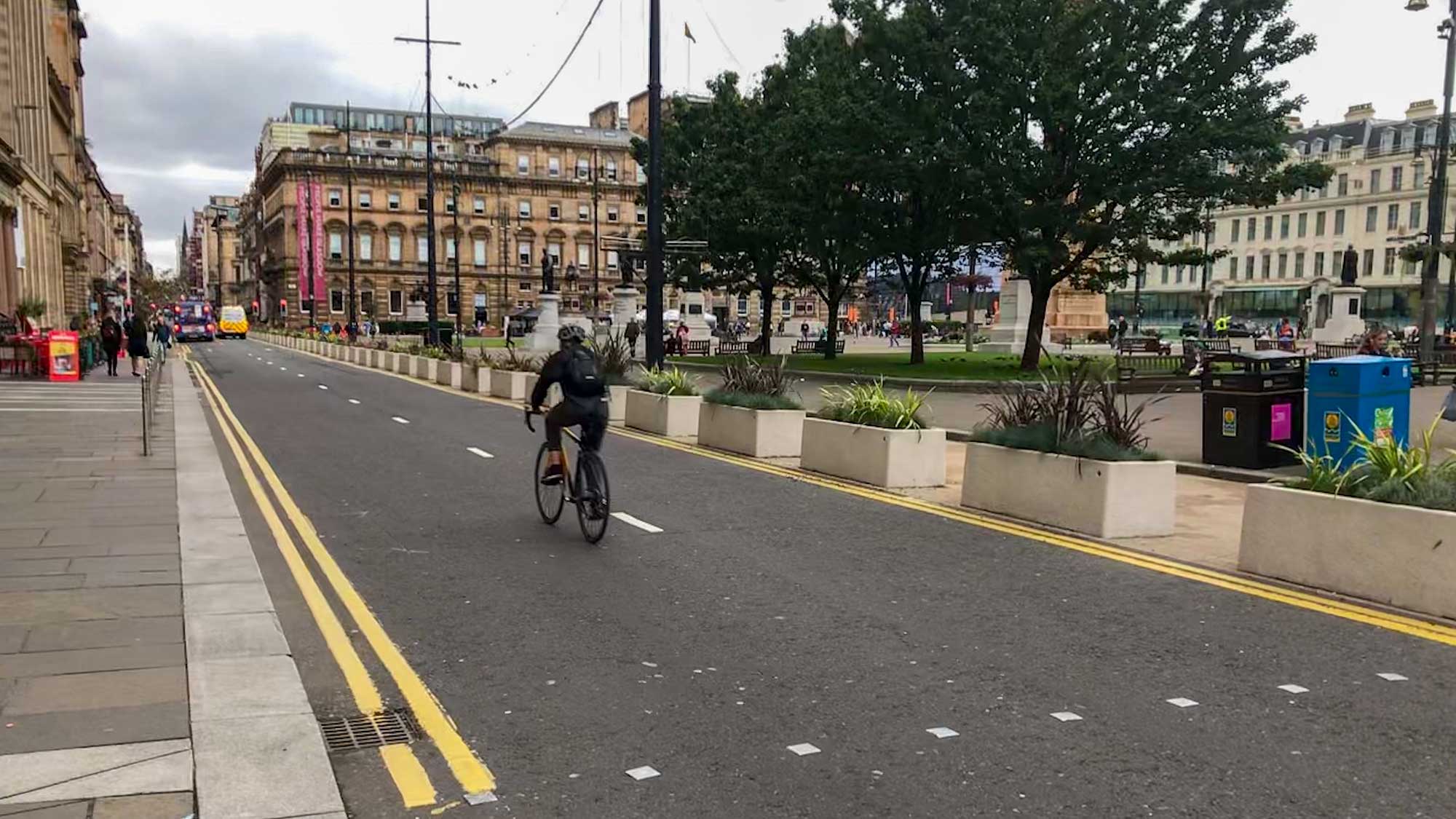
Yoker to Knightswood, route to BMX park, part 2, Shared Footway section proposals.

You may remember that last month we responded quite positively to the proposals for the southern part of this scheme?  That was the segregated cycleway sections; we had reservations but the council staff responded promptly and we are reasonably happy with that stage.

It is not the same at all with the second phase, which is all shared footway.  There appear to be contradictions between the drawings that are on the website (and reproduced here) and the paper drawings we were sent by post.  Just about everything is proposed to be at the Absolute Minimum dimension given in Cycling by Design – this document includes a Desirable Minimum, an Absolute Minimum and even gives reductions on the latter, which helps explain why some of the cycling facilities in Glasgow are as bad as they are.  Consultation on this part of the scheme closes this Friday, 08 December, so, if you can, please do get your views in over the next 2 days.

Given the disappointment in the scheme I have copied the 4 Councillors for the Ward, it’s Ward 13, into the letter, so that they get our concern first hand.  Two of these Councillors toured the ward on Friday with us.

The Council documents are here: YokerToKnightswood-Redetermination-220x85mm-RTO redetermination Statement of Reasons redetermination information Report  32518_TRO_01-Lincoln Ave 32518_TRO_01-Dyke Road 32518_TRO_01-Archerhill road

The GoBike response, objecting to the proposals is here: GoBike Yoker to Knightwood Redetermination 061217

Please do e-mail the Council if you have views on this scheme.

Councillor tour 11, the SNP two cycle round Ward 13, Scotstounhill / Garscadden, Friday 01 December

The 2 SNP councillors for Scotstounhill /Garscadden, Michael Cullen and Chris Cunningham (MSP Roseanna Cunningham’s brother) toured Ward 13 with GoBike committee member, Alasdair Macdonald and member, Neil Lovelock, on Friday 01 December.  They are all pictured above, in discussion with a local resident on the canalside.

Cllr Cullen posted to his Facebook page straight after the event, and has issued these tweets:
GoBike ride leader, Andy Preece, provided these points along his planned route, which the councillors noted on their tour: Councillor Ward Tour – Scotstoun, details
Neil has responded to the councillors on these issues:
Route cycled
Andy Preece provided this route: Councillor Ward Tour – Scotstoun map but the actual route cycled is here: http://www.mapmyride.com/workout/2600587315
Space for Cycling guide
See this PDF: space_for_cycling_guide_for_decision_makers  of the document that Neil handed across a copy on Friday.
Cycle path access points upgrade
See below for a few before and after photos of some of the improvements made to the access points back in Feb 2015.
Dock St planning approval
This is via West Dunbartonshire Council. Original application was submitted in 2012 and a revised version approved in 2016. Latest ref no is DC15/251 http://www.west-dunbarton.gov.uk/planning-building-standards/planning-applications/view-and-comment-on-planning-applications/
nextbike membership discount
Details of how to get the 50% discount are here:

After the GoBike AGM (29 November) two rides to look at infrastructure, and more in Glasgow

After our AGM and Public Meeting tomorrow, 7:30pm at the Admiral Bar, with what is very likely to be a lively discussion about cycle infrastructure in Glasgow, why not join one or both of our forthcoming rides to look in more detail at the city?  Both rides devised and led by Andy Preece, with further details on our Rides page. Continue reading “After the GoBike AGM (29 November) two rides to look at infrastructure, and more in Glasgow”

Contraflow Cycling, and a new Transform20 campaign

GoBike was invited to give a short presentation on a campaigning theme at the Transform Scotland AGM 2017 held in Glasgow City Chambers on 26 October.  We chose the topic of Contraflow Cycling and a summary of our talk is on the Contraflow Cycling campaign page on our website.  Contraflow is essential in our towns and cities to make them permeable for bikes.  One way streets were introduced to “improve” flow for cars, but this, as we know, has had the effect of increased vehicle speeds, increased vehicle use, increased congestion and increased pollution; we want our streets back.

At the AGM Transform Scotland launched their Transform 20 campaign: ‘As part of Transform Scotland’s 20th anniversary year we’ve launched a new campaign called #Transform20. This campaign focuses on offering an easy way for the public to communicate their ideas to transform transport in Scotland to become more eco-friendly, safer and easier to access.

Ideas can be simple and don’t require a detailed explanation. To submit your idea, please go to our website http://transform20.transform.scot, where you can submit a brief description of up to 200 words on how you think Scottish transport can be transformed. Your idea must be accompanied by a title (under 10 words) and there’s an option to upload a high quality picture to support your idea. You can also upload supporting documents or provide a link to further information if you wish.

GoBike has submitted our Contraflow campaign to this page, others have submitted their ideas too.  Why not have a look and submit your bee-in-your-bonnet campaigning idea?

If you like our Contraflow campaign please send in your contraflow picture, telling us where it is, to campaigning@gobike.org and we’ll add it to the web page.

Glasgow’s Fastlink – why are there “cycle upgrades” off the route?

Fastlink in Glasgow is absolutely not what we were initially led to expect.  It wavers from side to side of the road, cycling is allowed in this bit but not that, there is no accommodation for people exiting the southbound Clyde Cycle Tunnel to get across to the new hospital and one could go on.  Now we are aware that “cycle upgrades” are being carried out – in the form of shared footways off the main, direct route!  There has been no consultation that we are aware of.  The drawings we have are here: P_5100-S_100_Govan Road_Festival Park GA P_5100-S_101_Summertown_Rd and the letter we have sent, to quite a few people since we were not sure of the person in charge of this work is here: GoBikeFastlinkImprovementConcernsLetter251017 For simplicity we repeat the content of the letter below:

Continue reading “Glasgow’s Fastlink – why are there “cycle upgrades” off the route?”

Glasgow: Hyndland/Hughenden and Dowanhill West, Proposed Parking Controls, Exhibition, 30 October to 06 November

We have been made aware of this open consultation event.  Controlling car parking is critical, but we must ensure that it is not done at the expense of permeability for cycling, thus discouraging active travel.  Contraflow cycling lanes are becoming common throughout the city; Gordon Street, Dalnair Street and West Princes Street are just a few examples.  If streets that are currently two-way are proposed for one-way to allow the storage of motor vehicles on both sides without exempting bikes, as has happened in Dowanhill East, then please object.  The relevant part of the City Council’s design guide, Cycling by Design is clause 5.1.5

If you live in, work in, or travel through this area, do please get along to the consultation:

HYNDLAND / HUGHENDEN AND DOWANHILL WEST 

PROPOSED PARKING CONTROLS

PUBLIC CONSULTATION EXHIBITION – Venue: PARTICK LIBRARY

Exhibition Open to View from Monday 30 October to Monday 6 November 2017

On the following dates, council staff will also be present to answer queries & discuss proposals.

  • Tuesday 31 October, 10am to 4pm
  • Thursday 2 November, 10am to 6pm
  • Friday 3 November, 10am to 4pm

===========================================

Glasgow City Council are writing to inform you of the commencement of a voluntary consultation for the proposed Hyndland, Hughenden and Dowanhill West area parking controlled zone prior to the commencement of the statutory traffic regulation order (TRO) process.

Glasgow City Council is currently undertaking the development and introduction of significant parking control schemes throughout the Glasgow area.  This includes Hillhead, Garnethill and the Partick area.  Due to its scale, the Partick area has been split into separate schemes to facilitate the traffic regulation order (TRO) promotion and implementation process namely Partick, Hyndland/Hughenden, Dowanhill West areas and the Dumbarton Road/Argyle Street corridor.

The West End of Glasgow has excellent bus, train and subway transport links which unfortunately attracts commuters driving to the area and using the residential streets to park‑and‑ride resulting in the kerbside road space being sterilised by all day parking with indiscriminate and obstructive parking practices commonplace.  The introduction of parking controls is an effective way of managing the demand for the finite road space available by preventing all day parking thus reducing the traffic attracted to the area whilst increasing the turnover of parking spaces and improving the safety and traffic flow. Parking controls also maintains access for emergency service, refuse collection and delivery vehicles etc. and also assists the Council in undertaking routine road maintenance such as channel and gully cleaning work and road/ footway repairs.

Prior to the commencement of statutory traffic order process for the Hyndland, Hughenden and Dowanhill West schemes the Council is holding a public exhibition in Partick Library from Monday 30 October to Monday 6 November 2017. Council Officers will be in attendance to answer queries and discuss proposals on Tuesday 31 October, Thursday 2 November and Friday 3 November, as stated above.

A letter will be issued to all affected addresses within the proposed zone providing a brief summary of the proposals and will also inform of the public exhibition. 

Pre-meeting Info – Statutory Process for Parking Restrictions

Pre-meeting Info – Glasgow City Councils Local Transport Strategy in relation to Parking

Pre-meeting Info – Existing Parking Zones within Glasgow


Glasgow Councillor Tour 9, Thursday 19 October, Ward 23, Partick East / Kelvindale, Walking Tour with Green Councillor, Martin Bartos

On the evening of Thursday 19 October, GoBike Convenor, Tricia Fort, and member, Johnston Orr, met with Councillor Martin Bartos, for a short walking tour of Ward 23, Partick East/Kelvindale.  We took more or less the same route that we had covered with the other 3 councillors for the ward, from near Byres Road along Highburgh/Hyndland Road to Great Western Road and we walked because Martin is not yet back on his bike following a collision with a taxi some time ago.  This is the only ward where all 4 councillors have met with us, setting a great example to all the other wards!  Johnston and Martin are pictured below:

From east to west, our discussion covered, first of all, Byres Road, which is currently being considered for redevelopment.  Martin is concerned at the lack of ambition being shown in the current Glasgow City Council proposals.  We have thus put him in touch with the GoBike grouping that is developing alternative proposals, see: https://space4peoplebyresroad.wordpress.com/2017/10/20/our-vision/ and the photo at the top of this blog is option 2 showing local access and a bus route with cycle lanes both sides.  Remember that there’s a ride-out tomorrow along the route – details in the link.

Our next point of discussion was the lack of access into Dowanhill for bikes from Highburgh Road.  Caledon Street, Dowanhill Street, Beaumont Gate and Hyndland Street are all one-way southwards with no exception for cycles and the only legal option is to turn right into Crown Road South – which is on a bend, and it’s a busy road.  Contraflow cycling on one-way streets is the default position in Cycling by Design (clause 5.i.5), the City Council’s chosen design guide, so why doesn’t it apply here, where there is a toucan crossing to aid the passage of people with bikes up Dowanhill Street?  It should also be noted that contraflow cycling would reduce traffic speeds on these streets.

Third, we noted the good intention of providing disabled parking bays, also noted on our walking tour with Councillors Kenny McLean and Martin Rhodes, which extend right out to the cycle lane – potentially increasing the number of disabled people in the area!

Fourth, we looked at the buildout at the end of the row of shops on Hyndland Road.  The eastbound painted cycle lane, missing since the junction with Clarence Drive, reappears here, right on the bend and just at the pinch point where the road is at its narrowest.  The buildout has been put in place apparently to provide 2 loading bays, which are being misused as parking bays – just where the cycle lane could have been.

Fifth, we noted the blockage in the access provided to Prince Albert Road; why is no action taken against parking at all these cycle accesses?

Sixth, we discussed the potential of access via Hughenden Lane to the sports facilities and Gartnavel Hospital and points further west.

Seventh, we looked at the junction of Hyndland Road with Great Western Road, a scene of constant red-light jumping by cars and constant misuse of the left-turning lane to go straight on to Clevedon Road.  Why is no action taken to remedy this?

A further point of discussion was the type of cycle facility needed to encourage cycling.  While a segregated cycle lane is needed on either side of Great Western Road, which is a major route into the city, a two-way segregated cycle lane would be far better than the current position on Hyndland/Highburgh Road if the Council persists in allowing the storage of private property (colloquially known as car parking) on the road but reduces it to one side only.

Martin asked about traffic evaporation when roads are closed to motor vehicles, or when access is reduced, and Johnston has provided this information:

“The economic case for building cycle lanes – https://www.citylab.com/life/2013/12/safer-streets-pay-businesses/7880/ from 2013 and a pretty comprehensive roundup from 2015 https://www.citylab.com/solutions/2015/03/the-complete-business-case-for-converting-street-parking-into-bike-lanes/387595/

Closing roads to cars and traffic evaporation – the Wikipedia page on Induced Demand is a good place to start as it leads into a section on traffic evaporation https://en.m.wikipedia.org/wiki/Induced_demand and the academic study referencing UK cases (I was wrong, there are some!) – https://web.wpi.edu/Pubs/E-project/Available/E-project-051109-062746/unrestricted/D09_Traffic_Final_Report.pdf and the same studies referenced by the EU paper at http://ec.europa.eu/environment/pubs/pdf/streets_people.pdf

Plenty to digest there, and some of it is heavyweight stuff, so maybe try this news article on what Paris is doing right now for some real-world evidence from a European city’s current policy decisions – https://www.fastcompany.com/3064157/when-paris-closed-a-major-road-to-cars-half-its-traffic-just-disappeared

Glasgow Councillor Tour 8, Ward 6, Pollokshields, with Green Party Councillor, Jon Molyneux, Thursday 19 October 2017

On the afternoon of Thursday 19 October, Councillor Jon Molyneux, Green Party, met GoBike convenor, Tricia Fort and GoBike members, Bill Fraser, who is also on Pollokshields Community Council, Bob Downie and Nick Kempe for a cycle tour of Ward 6.  We were waved off from Pollokshaws Road at Shawlands Cross by Baillie Hanif Raja, Labour Party, who doesn’t cycle but wished us well.

Details of the route planned for us by GoBike ride leader, Andy Preece are given here: Councillor Ward Tour – Pollokshields map and his notes are here: Councillor Ward Tour – Pollokshields  We deviated slightly from the route and the actual route is shown here: 

So, what did we notice apart from the information given in Andy’s notes?  We left our meeting point on Pollokshaws Road, the most heavily cycled route in Glasgow, that has next to no cycle facilities and went along Moss-Side Road, past Shawlands Academy.  There were cars parked right along, with no sign of any assistance for parents or pupils who might want to cycle to school.  We made our way over the railway at Crossmyloof Station, with only an Advance Stop Line for anyone who wants to cycle to Hutchesons’ Grammar School, and down into Titwood Road.

Springkell Avenue is a wide, quiet road, where all the houses have gardens and driveways – so why do they park on the road?  We then came to this, where apparently a nearby housing development is having an adverse effect on the railway bridge:

Yes, there was room to get through on our bikes, so why isn’t it signed for bikes as well as pedestrians?  Where’s the permeability?

At the end of Springkell Avenue, a pleasure to cycle on, we came to the path down to Dumbreck Road.  Apart from the spreading vegetation over the path, there is no lighting on this path, nor on the section that goes all the way to Nithsdale Road – not a winter commuter route then!  At Dumbreck Road we joined the carriageway; a tricky manoeuvre since the toucan crossing and lights seem to assume that someone on a bike will be going into Pollok Park not over the motorway towards Bellahouston Park.  We checked out the exit from Bellahouston Park, thinking that quite a few families from the area might want to cycle to and from it.  The only crossing over Dumbreck Road is a pedestrian one; there is no traffic signal for cars or bikes exiting the park.

As the picture shows, there are no cycle facilities on NIthsdale Road, a useful route across to the east of the ward, and with 2 lanes of traffic coming towards Dumbreck Road, it’s quite a narrow access for bikes as well as cars.  Later, we turned into Maxwell Drive, where cars park right over the painted cycle lanes, or are parked so close to the cycle lane that an opening door could seriously damage a bike and its rider.

We made our way to Albert Drive where the Community Council has put much effort into trying to prevent cars being parked at street corners.  Double yellow lines have been painted on them all, but they are not mandatory until the necessary signs are in place.  The signs are not in place – what an omission by the City Council!

On the eastern end of Albert Drive, we came upon a car parked on the cycle lane and then the cycle lane disappeared under a road narrowing scheme designed to protect the weak railway bridge:

So, one wonders, why wasn’t the bike lane continued, but with segregation, to narrow the road?  Where are people on bikes supposed to go?  Into the narrow roadway or on the footway?  After this point the cycle lanes disappear again under parked cars.

We took a left on Barrland Street to avoid the busy Pollokshaws Road but we did go to the eastern end of Maxwell Road, where there are no formal dropped kerbs to Pollokshaws Road but tarmac ramps were made for a running race a couple of years ago.  Fortunately, they have not been removed.

The Community Council, we heard, are working towards improving Maxwell Road by liaising with house-builders and improving the parking situation.

We took a look at Forth Street, the home of Soul Riders, where recent parking changes included making the street one-way, and not exempting bikes.  So, it’s either a long detour or a technically illegal ride on the footway to get to their premises.  Where is the encouragement to cycle?  Where is the permeability?

At the new school on St Andrew’s Road, we cycled along McCulloch Street, that has been nicely traffic-calmed, and which gives much better access to Shields Road and the crossing to the South-West City Way.  From this cycle way, just about the best in the city, we made the awkward right turn at West Street Subway Station to travel along all the painted cycle lanes back to Pollokshaws Road and we finished our tour alongside the cars parked on the contraflow lane linking Pollokshaws Road with Eglinton Street.

The potential is there in this ward to encourage cycling, but a bit of enlightened thinking is needed to protect the existing cycle lanes and to improve access and permeability.


Councillor Tour 7, Drumchapel / Anniesland, Ward 7, Thursday 12 October

Congratulations and a gold star to Councillor Elspeth Kerr, SNP, pictured above wearing purple, who doesn’t own a bike but yet cycled 6.5 miles round her ward on Thursday with Anne Glass, from Drumchapel Cycle Hub, also pictured and GoBike Convenor Tricia Fort.  We are indebted to Anne and the Drumchapel Cycle Hub for the loan of Elspeth’s purple bike, shown above.  The route we took, a shortened version of one devised by Andy Preece,  is shown below:

Here’s a guide to the route: Councillor Ward Tour – Anniesland & Drumchapel final

There are some busy main roads in this ward and we cycled on the footway along Drumry Road East, through the roundabouts to Great Western Road, then from the point where we left the canal path up Great Western Road to Knightswood Cross and again at the end of our ride along Drumchapel Road and back up Drumry Road East to the Hub.  There are no cycle facilities on these busy roads and although it is not correct to cycle on the footway, it is far safer for someone like Elspeth, who is not confident on the road.

So, in this relatively poor area with fairly low car ownership, what did we see apart from the lack of cycle facilities?  As Andy points out in his notes, when we crossed from the Great Western Retail Park to the south side of Great Western Road, the footway is shared.  At the Glasgow boundary, with no change of width in the footway, this stops, and people on bikes are directed to the canal towpath.  What if they want to go straight up Great Western Road towards Knightswood?  Tough, and they encounter a lack of dropped kerbs if they do venture here on a bike or they are pushing a pram or a wheelchair.

We went on the canal towpath for quite a bit of this ride, and one has to be aware of pedestrians and dogs.  There are ground lights for part of the way, but to ensure these are effective, vegetation must be kept back.  At Lock 35, we crossed to the north side to look at the garden that has been developed by volunteers, including members of GoBike:

Back on Great Western Road, we noticed that, although laybys have been provided for parked cars, some drivers prefer to leave their car in the inside lane of this 3-lane road!

This picture shows 1 car in the layby, 3 parked in the inside lane, and 1 car actually moving in the middle lane.  This doesn’t leave much room for bikes, or buses.  This dual carriageway, a major artery to the city centre, has plenty of room for a cycle way on each side.

At Knightscliffe Avenue we cut in round the Netherton Community Centre and onto the path, Temple Walkway, which runs from Glencoe Street right past the Community Centre and the disused Temple Swimming Pool to Shafton Road.  The path has a good surface and could be used much more for cycling and walking if it were lit.

Shafton Road took us round, via Avenel Road to the canal, with a steep access path and we cycled west as far as Blairdardie Road Footbridge.  From here, with no dropped kerb to help us down to the roadway, we made our way along Moraine Avenue, and to the path that took us under the railway to Essenside Avenue and more locations needing dropped kerbs:

Here, at the access to the path leading to Drumchapel Road, the fence is blocking the very bit of the kerb that is dropped, albeit only slightly.  So, all in all, this is not an area that is active-travel-friendly, but with much potential for improvement.

Glasgow Councillor Tour, Ward 7, Langside, 11 October

On Wednesday evening, 11 October 2017, a group of GoBike members met Tanya Wisely, Green Party Councillor for Ward 7 to tour her ward and to see how the ward can potentially link into the proposed South City Way.  The photo above shows, from left to right, Graham Muirhead, Meredith Muirhead, Tanya Wisely, Tricia Fort, Bill Wurthmann and Bob Downie at our meeting point, Langside Hall.  This photo and the ones below taken by Ajit Panickar, a GoBike member who also joined us for the tour.

Here’s the route we followed: https://www.strava.com/activities/1225746006   and the map:

So, what did we experience?

  • Streets between tenements with cars parked both sides, leaving little room for moving vehicles.
  • Dropped kerbs blocked by parked cars – on Carmichael Place (at the end of the White Cart Cycle Route path) and at the end of our ride hampering cycle access to Balvicar Street from Pollokshaws Road.
  • A very tricky road crossing from Sinclair Drive over Battlefield Road to Grange Road.
  • No cycle facilities leading to the New Victoria Hospital, but there is a narrow cycle lane marked on the footway on Queen’s Park Street, circling part of the hospital, which doesn’t connect into any cycle lane at the Grange Road or the Prospecthill Road end.
  • A nice, wide road past Hampden connecting Cathcart Road to Aikenhead Road, where there is then a very narrow shared footway with a long wait at the toucan crossing to cross to an equally narrow shared footway, part of the “Cathkin Braes Route”.
  • Cars parked on the roadway outside houses, leaving little room for bikes, cars, vans to move along and certainly not an environment where children could play outside their gardens.
  • New flats and houses in Toryglen with no cycle lane access.
  • A narrow, dark path from Prospecthill Circus to Polmadie Road; if this were widened and lit for its full length and the glass cleared regularly, and the junction area of Polmadie Road to Aikenhead Road to Dixon Road made less daunting for people on bikes it would provide an excellent link from Toryglen to Govanhill and to the forthcoming South City Way.  Access to the South City Way from other parts of the ward is feasible – if the route could be continued around Queen’s Park – on both sides (Langside Road/Queen’s Drive and Pollokshaws Road), while a route through the park is fine for a leisurely cycle ride in daylight.
  • The curious nature of some streets,eg Dixon Road, being adorned with blue signs indicating that this is a  “Route recommended for pedal cycles on the main carriageway of a road”.  One wonders what the criteria are to merit the signage.

Some details of the route from Andy Preece, who devised the tour – although we deviated a little at the end to check out the access at Balvicar Street are here: Councillor Ward Tour – Langside v2

Car blocking the dropped kerb at the end of Carmichael Place where there is access to and from the riverside path through to Tantallon Road – and yes, the car is parked on the double yellow lines.

Aikenhead Road at Hampden

Car blocking the cut-through from Balvicar Road to Pollokshaws Road, the end of the route we took.