Consultations Digest, Issue 5, 20 March 2018: UK and Glasgow consultations in this issue.

Yes, we’ve a UK government request for your views in this issue, so do get your responses in. They say that they want more of us out on our bikes or walking so here’s your opportunity to tell them what needs to be done to facilitate that.  See section 1.3 below. Continue reading “Consultations Digest, Issue 5, 20 March 2018: UK and Glasgow consultations in this issue.”

Consultations Digest Issue 3, 20 February 2018 – Stushies brewing: Elmbank Street Glasgow and Cowgate Kirkintilloch


Yes, folks, we have a couple of contentious situations in this issue.  See Section 3, Consultations Feedback where we discuss whether Elmbank Street will provide northbound access to the Sauchiehall Street cycle lane, but first, see Section 1 for the threat to the so-called “shared space” along Cowgate, the main street in Kirkintilloch.  Continue reading “Consultations Digest Issue 3, 20 February 2018 – Stushies brewing: Elmbank Street Glasgow and Cowgate Kirkintilloch”

Yoker to Knightswood, route to BMX park, part 2, Shared Footway section proposals.

You may remember that last month we responded quite positively to the proposals for the southern part of this scheme?  That was the segregated cycleway sections; we had reservations but the council staff responded promptly and we are reasonably happy with that stage.

It is not the same at all with the second phase, which is all shared footway.  There appear to be contradictions between the drawings that are on the website (and reproduced here) and the paper drawings we were sent by post.  Just about everything is proposed to be at the Absolute Minimum dimension given in Cycling by Design – this document includes a Desirable Minimum, an Absolute Minimum and even gives reductions on the latter, which helps explain why some of the cycling facilities in Glasgow are as bad as they are.  Consultation on this part of the scheme closes this Friday, 08 December, so, if you can, please do get your views in over the next 2 days.

Given the disappointment in the scheme I have copied the 4 Councillors for the Ward, it’s Ward 13, into the letter, so that they get our concern first hand.  Two of these Councillors toured the ward on Friday with us.

The Council documents are here: YokerToKnightswood-Redetermination-220x85mm-RTO redetermination Statement of Reasons redetermination information Report  32518_TRO_01-Lincoln Ave 32518_TRO_01-Dyke Road 32518_TRO_01-Archerhill road

The GoBike response, objecting to the proposals is here: GoBike Yoker to Knightwood Redetermination 061217

Please do e-mail the Council if you have views on this scheme.

Councillor Tour 10, Govan, Ward 5 with Councillor Allan Young (Green Party), 11 November 2017

On Saturday 11th November 2017, GoBike members Bob Downie and Andy Winter, and Rumina Kakati (who leads rides enjoyed by new, nervous and lapsed cyclists) met with Allan Young, the Green councillor for Govan ward, to go on a tour of some of the cycle facilities in the ward. Committee member Brenda Lillicrap organised the ride but was prevented from doing all but the start of the tour by a puncture.  We were delighted that Allan was available to come out with us and hope that the other three ward councillors will be able to come for a similar tour in future. The invitation remains open . Our route took us out and back from Cessnock subway station, past Bell’s Bridge, the Science Centre, Queen Elizabeth University Hospital and Govan centre, all the while critiquing the cycle facilities we saw and used, good and bad.

Our start was in Walmer Crescent, a short one-way street with slow traffic, no junctions, and a sharp corner at both ends – ideal for the council’s declared default of permitting contraflow cycling on one-way streets. Not yet though.

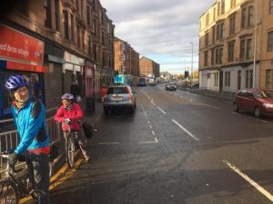
Picture 1, shown above: Start – Govan Ward 5 Tour 11/11/17, Rumina Kakati, Allan Young, Andy Winter and Bob Downie at Cessnock Station

Picture 2Map Route taken on Govan Ward 5 tour 11/11/17. Numbered points refer to photograph locations below

Our route initially took us north on the signed Cycle Route 7 along Cessnock Street, Brand Street – now with perpendicular parking for the new flats along the south side, a potential hazard for cyclists on this well-used route – and Govan Road. We able to see the ‘improvements’ being made connected with Fastlink. We wondered about the value of spending money on a grade-separated cycleway alongside a road where the only permitted traffic is buses and taxis – and there aren’t any bus routes. There are much stronger candidate areas for cycle infrastructure spending even when the funding is ring-fenced for work connected with Fastlink.

Our first major hurdle was where Govan Road joins Pacific Drive. At these traffic lights, cyclists are invited to behave like pedestrians and cross Pacific Drive to cycle westward on the north-side pavement. To cross, cyclists must wait for 3 individual sets of pedestrian controlled lights, the first to cross the two lanes of the Fastlink bus corridor (not available for cycle use), followed by lights for each lane of ordinary traffic. The presence of extensive pedestrian barriers makes crossing by more than 2-3 bikes at a time very difficult. The experienced cyclists will almost certainly ignore the invitation to use this crossing and travel westward on the road. Those new to cycling (or with tandems, trailers or cargo bikes) are discouraged by tight turns made more difficult by poles, railings and control boxes, especially when there are pedestrians or other cyclists to consider.

While manoeuvring the crossing we agreed that plans to designate the footway on the south side for shared use (right through the bus shelter, and next to the sparsely used Fastlink carriageway) were a frustratingly marginal improvement, and we wondered why no effort had been made to route cyclists behind the Village Hotel to get toward’s Bells Bridge. There is already a crossing across Pacific Drive opposite the Bell’s Bridge path, albeit one offset from the desire line and with yet more barrier/pole/box obstacles.

Picture 3CrossToPavement We were invited to behave as pedestrians and use the pavement on the north side of Pacific Drive (point 1 on map)

It was generally agreed that the new path from Pacific Drive to Bell’s Bridge then continuing along the river in front of the BBC and the Science Centre was excellent. We wished it were possible for the riverside path to extend eastwards under the Clyde Arc Bridge. Back at Govan Road we continued westward and on to Golspie Street, which was re-engineered to accommodate the Fastlink carriageway. This gives it the appearance of a fast dual-carriageway, by-pass type of road, with its absence of active frontages and sweeping turns at the junctions. With the two directions of normal traffic using the single non-Fastlink carriageway it feels like a hostile piece of road for cyclists. This section is difficult to avoid for east-west travel because of the barrier of the lines into the subway depot. The layout of the both junctions on this stretch encourages drivers to make fast left turns, with the potential for left-hooking cyclists. The extensive pedestrian barriers at the junction with Harmony Row hem cyclists in in a manner that is worrying. There is nowhere for cyclists to escape if cars come too near.

Picture 4Barriers Extensive barriers at the junction of Golspie Street and Harmony Row (point 2 on map)

A newish, good quality pedestrian-cycle route took us the 200m from Golspie Street to Langlands Road. This was free of motor traffic and wide enough for cyclists and pedestrian to easily pass in both directions. A useful improvement would be a dropped kerb at the eastern end to allow easy access for west-bound cyclists without having to mingle with pedestrians at the pelican crossing.

Picture 5SharedPath Using the Golspie Street to Langlands Road cycle/pedestrian route (point 3 on map)

On Langlands Road significant sections of the advisory cycle lanes, only denoted by painted lines, were blocked by parked cars on both sides of the road. We understand these painted lanes form part of the ‘active travel access’ for the newly enlarged hospital. Allowing parking in cycle lanes shows that cyclists lack any real status on Glasgow’s roads. Cycle users deserve better.

Picture 6CarsInBikeLane Cars parked in the Langlands Road cycle lane (point 4 on map)

We carried on along Langlands Road to the underpass beneath the A739, the busy dual carriageway leading to the Clyde Tunnel. This underpass gives cycle access to the Queen Elizabeth University Hospital, but the large amount of graffiti and general feel of dilapidation gives it an edgy feel. This is not a facility most people would like to use at night.

Picture 7Graffiti Pedestrian/cycle underpass beneath the A739 to the Queen Elizabeth University Hospital. A highly graffitied and unwelcoming place (point 5 on map)

The feeling of dilapidation continued on the west side of the A739 where the first entrance to the hospital had no dropped kerb as well as being very rough, and needing another tight turn to negotiate the bollards in the underpass entrance.

Picture 8HospEntrance Off-putting entrance to the QEUH. Note the lack of dropped kerb (point 6 on map)

We continued north beside the A739 on an excellent shared pedestrian/cycle path which continued along Moss Road. At the junction with Peninver Drive a new pedestrian/cycle crossing has been installed but the timing of the lights was so slow (about 3 minutes) that no one was inclined to wait and we all took the chance to cross when the traffic appeared clear. The timing of these lights needs to be reviewed.

Picture 9LongWait Very slow timing of the lights allowing cycle crossing from Moss Road to Peninver Drive (point 7 on map)

Onward to Govan Road where we noted that parking was allowed by the shops near the junction with Holmfauldhead Place. We were told that this parking can at times cause significant congestion leading to cyclists being squeezed on the road, with drivers overtaking without allowing sufficient space.

Picture 95ParkingSqueeze Govan Road near the junction with Holmfauldhead Place. A busy road restricted by allowing on-street parking. Cyclists get squeezed here (point 8 on map)

A major problem in this area is the difficulty that south-going cyclists have turning west along Govan Road when they exit the Clyde Cycle Tunnel. To cross Govan Road “by the book” is so slow and complex that few cyclists comply and simply cross Govan Road when and where they can. The lack of a simple and safe crossing is simply unacceptable.

Our tour concluded with a ride through the centre of Govan and discussion as to how a dedicated cycle route through the main street of Govan Road could be a significant feature as part of the area regeneration.

Overall we were underwhelmed by the cycle facilities that we saw and used in Govan. Short sections were excellent but on the whole we felt that most were let down by poor design and poor implementation. The biggest issues are the lack of interconnectivity between adequate facilities and the method the planners use to take cyclists across main roads by requiring cyclists to behave like pedestrians and use complex, slow, barriered crossings. These are tricky for inexperienced cyclists to manoeuvre through, and experienced cyclists are likely to ignore the lights and cross as and when they see a gap in the traffic. The perennial problem of cars parking in non-segregated cycle lanes remains an issue in Govan as almost everywhere else in the UK.

We hope that Councillor Allan Young will be able to use the information gained in this tour to inform him in his work as a councillor and as ever, GoBike are here to help should he (or any of the other three Govan councillors) have any further questions.

We have one more tour planned for Friday 01 December with Councillors Cullen and Cunningham around Ward 13, Garscadden/Scotstounhill.  Then, unless we can choose daylight during the winter, we’ll be hoping to resume in the spring – if councillors are minded to join us!
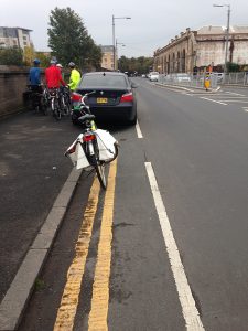
Knightswood Park BMX track – Cycle Route access, part 1, Segregated


Glasgow City Council are planning a part segregated and part shared footway cycle route access to Knightswood Park, to be built in time for the 2018 European BMX Championships, for which the park will be a venue.

There was public consultation in August but we were not formally told of this although some of our members went along.  The Traffic Regulation Order that has been issued is sparse on information but after asking questions of the Council Officer who is dealing with the scheme we were sent drawings earlier this week.  These have helped to formulate our response: GoBike Yoker to Knightwood Sustainable Transport Corridor 1 171117  This is only to the segregated cycleway part of the scheme.  The more contentious part is the shared footway element and we’ll get our response to that out well before the closing date next month.

Consultation on this segregated element closes on 19 November and the TRO documents are here: YokerToKnightswood-NoticeOfProposals-230x114mm-RTO TRO no waiting no loading cycle track 1 of 3 TRO corner protection 3 of 3 TRO corner protection 2 of 3 TRO information Report

In summary, we support the segregated cycleway but have concerns about junction treatment, management of parking, the cycleway width behind floating bus stops, the robustness of the orcas without bollard reinforcement and the connectivity of the scheme.

Glasgow Councillor Tour 9, Thursday 19 October, Ward 23, Partick East / Kelvindale, Walking Tour with Green Councillor, Martin Bartos

On the evening of Thursday 19 October, GoBike Convenor, Tricia Fort, and member, Johnston Orr, met with Councillor Martin Bartos, for a short walking tour of Ward 23, Partick East/Kelvindale.  We took more or less the same route that we had covered with the other 3 councillors for the ward, from near Byres Road along Highburgh/Hyndland Road to Great Western Road and we walked because Martin is not yet back on his bike following a collision with a taxi some time ago.  This is the only ward where all 4 councillors have met with us, setting a great example to all the other wards!  Johnston and Martin are pictured below:

From east to west, our discussion covered, first of all, Byres Road, which is currently being considered for redevelopment.  Martin is concerned at the lack of ambition being shown in the current Glasgow City Council proposals.  We have thus put him in touch with the GoBike grouping that is developing alternative proposals, see: https://space4peoplebyresroad.wordpress.com/2017/10/20/our-vision/ and the photo at the top of this blog is option 2 showing local access and a bus route with cycle lanes both sides.  Remember that there’s a ride-out tomorrow along the route – details in the link.

Our next point of discussion was the lack of access into Dowanhill for bikes from Highburgh Road.  Caledon Street, Dowanhill Street, Beaumont Gate and Hyndland Street are all one-way southwards with no exception for cycles and the only legal option is to turn right into Crown Road South – which is on a bend, and it’s a busy road.  Contraflow cycling on one-way streets is the default position in Cycling by Design (clause 5.i.5), the City Council’s chosen design guide, so why doesn’t it apply here, where there is a toucan crossing to aid the passage of people with bikes up Dowanhill Street?  It should also be noted that contraflow cycling would reduce traffic speeds on these streets.

Third, we noted the good intention of providing disabled parking bays, also noted on our walking tour with Councillors Kenny McLean and Martin Rhodes, which extend right out to the cycle lane – potentially increasing the number of disabled people in the area!

Fourth, we looked at the buildout at the end of the row of shops on Hyndland Road.  The eastbound painted cycle lane, missing since the junction with Clarence Drive, reappears here, right on the bend and just at the pinch point where the road is at its narrowest.  The buildout has been put in place apparently to provide 2 loading bays, which are being misused as parking bays – just where the cycle lane could have been.

Fifth, we noted the blockage in the access provided to Prince Albert Road; why is no action taken against parking at all these cycle accesses?

Sixth, we discussed the potential of access via Hughenden Lane to the sports facilities and Gartnavel Hospital and points further west.

Seventh, we looked at the junction of Hyndland Road with Great Western Road, a scene of constant red-light jumping by cars and constant misuse of the left-turning lane to go straight on to Clevedon Road.  Why is no action taken to remedy this?

A further point of discussion was the type of cycle facility needed to encourage cycling.  While a segregated cycle lane is needed on either side of Great Western Road, which is a major route into the city, a two-way segregated cycle lane would be far better than the current position on Hyndland/Highburgh Road if the Council persists in allowing the storage of private property (colloquially known as car parking) on the road but reduces it to one side only.

Martin asked about traffic evaporation when roads are closed to motor vehicles, or when access is reduced, and Johnston has provided this information:

“The economic case for building cycle lanes – https://www.citylab.com/life/2013/12/safer-streets-pay-businesses/7880/ from 2013 and a pretty comprehensive roundup from 2015 https://www.citylab.com/solutions/2015/03/the-complete-business-case-for-converting-street-parking-into-bike-lanes/387595/

Closing roads to cars and traffic evaporation – the Wikipedia page on Induced Demand is a good place to start as it leads into a section on traffic evaporation https://en.m.wikipedia.org/wiki/Induced_demand and the academic study referencing UK cases (I was wrong, there are some!) – https://web.wpi.edu/Pubs/E-project/Available/E-project-051109-062746/unrestricted/D09_Traffic_Final_Report.pdf and the same studies referenced by the EU paper at http://ec.europa.eu/environment/pubs/pdf/streets_people.pdf

Plenty to digest there, and some of it is heavyweight stuff, so maybe try this news article on what Paris is doing right now for some real-world evidence from a European city’s current policy decisions – https://www.fastcompany.com/3064157/when-paris-closed-a-major-road-to-cars-half-its-traffic-just-disappeared

Glasgow Councillor Tour 8, Ward 6, Pollokshields, with Green Party Councillor, Jon Molyneux, Thursday 19 October 2017

On the afternoon of Thursday 19 October, Councillor Jon Molyneux, Green Party, met GoBike convenor, Tricia Fort and GoBike members, Bill Fraser, who is also on Pollokshields Community Council, Bob Downie and Nick Kempe for a cycle tour of Ward 6.  We were waved off from Pollokshaws Road at Shawlands Cross by Baillie Hanif Raja, Labour Party, who doesn’t cycle but wished us well.

Details of the route planned for us by GoBike ride leader, Andy Preece are given here: Councillor Ward Tour – Pollokshields map and his notes are here: Councillor Ward Tour – Pollokshields  We deviated slightly from the route and the actual route is shown here: 

So, what did we notice apart from the information given in Andy’s notes?  We left our meeting point on Pollokshaws Road, the most heavily cycled route in Glasgow, that has next to no cycle facilities and went along Moss-Side Road, past Shawlands Academy.  There were cars parked right along, with no sign of any assistance for parents or pupils who might want to cycle to school.  We made our way over the railway at Crossmyloof Station, with only an Advance Stop Line for anyone who wants to cycle to Hutchesons’ Grammar School, and down into Titwood Road.

Springkell Avenue is a wide, quiet road, where all the houses have gardens and driveways – so why do they park on the road?  We then came to this, where apparently a nearby housing development is having an adverse effect on the railway bridge:

Yes, there was room to get through on our bikes, so why isn’t it signed for bikes as well as pedestrians?  Where’s the permeability?

At the end of Springkell Avenue, a pleasure to cycle on, we came to the path down to Dumbreck Road.  Apart from the spreading vegetation over the path, there is no lighting on this path, nor on the section that goes all the way to Nithsdale Road – not a winter commuter route then!  At Dumbreck Road we joined the carriageway; a tricky manoeuvre since the toucan crossing and lights seem to assume that someone on a bike will be going into Pollok Park not over the motorway towards Bellahouston Park.  We checked out the exit from Bellahouston Park, thinking that quite a few families from the area might want to cycle to and from it.  The only crossing over Dumbreck Road is a pedestrian one; there is no traffic signal for cars or bikes exiting the park.

As the picture shows, there are no cycle facilities on NIthsdale Road, a useful route across to the east of the ward, and with 2 lanes of traffic coming towards Dumbreck Road, it’s quite a narrow access for bikes as well as cars.  Later, we turned into Maxwell Drive, where cars park right over the painted cycle lanes, or are parked so close to the cycle lane that an opening door could seriously damage a bike and its rider.

We made our way to Albert Drive where the Community Council has put much effort into trying to prevent cars being parked at street corners.  Double yellow lines have been painted on them all, but they are not mandatory until the necessary signs are in place.  The signs are not in place – what an omission by the City Council!

On the eastern end of Albert Drive, we came upon a car parked on the cycle lane and then the cycle lane disappeared under a road narrowing scheme designed to protect the weak railway bridge:

So, one wonders, why wasn’t the bike lane continued, but with segregation, to narrow the road?  Where are people on bikes supposed to go?  Into the narrow roadway or on the footway?  After this point the cycle lanes disappear again under parked cars.

We took a left on Barrland Street to avoid the busy Pollokshaws Road but we did go to the eastern end of Maxwell Road, where there are no formal dropped kerbs to Pollokshaws Road but tarmac ramps were made for a running race a couple of years ago.  Fortunately, they have not been removed.

The Community Council, we heard, are working towards improving Maxwell Road by liaising with house-builders and improving the parking situation.

We took a look at Forth Street, the home of Soul Riders, where recent parking changes included making the street one-way, and not exempting bikes.  So, it’s either a long detour or a technically illegal ride on the footway to get to their premises.  Where is the encouragement to cycle?  Where is the permeability?

At the new school on St Andrew’s Road, we cycled along McCulloch Street, that has been nicely traffic-calmed, and which gives much better access to Shields Road and the crossing to the South-West City Way.  From this cycle way, just about the best in the city, we made the awkward right turn at West Street Subway Station to travel along all the painted cycle lanes back to Pollokshaws Road and we finished our tour alongside the cars parked on the contraflow lane linking Pollokshaws Road with Eglinton Street.

The potential is there in this ward to encourage cycling, but a bit of enlightened thinking is needed to protect the existing cycle lanes and to improve access and permeability.


Councillor Tour 7, Drumchapel / Anniesland, Ward 7, Thursday 12 October

Congratulations and a gold star to Councillor Elspeth Kerr, SNP, pictured above wearing purple, who doesn’t own a bike but yet cycled 6.5 miles round her ward on Thursday with Anne Glass, from Drumchapel Cycle Hub, also pictured and GoBike Convenor Tricia Fort.  We are indebted to Anne and the Drumchapel Cycle Hub for the loan of Elspeth’s purple bike, shown above.  The route we took, a shortened version of one devised by Andy Preece,  is shown below:

Here’s a guide to the route: Councillor Ward Tour – Anniesland & Drumchapel final

There are some busy main roads in this ward and we cycled on the footway along Drumry Road East, through the roundabouts to Great Western Road, then from the point where we left the canal path up Great Western Road to Knightswood Cross and again at the end of our ride along Drumchapel Road and back up Drumry Road East to the Hub.  There are no cycle facilities on these busy roads and although it is not correct to cycle on the footway, it is far safer for someone like Elspeth, who is not confident on the road.

So, in this relatively poor area with fairly low car ownership, what did we see apart from the lack of cycle facilities?  As Andy points out in his notes, when we crossed from the Great Western Retail Park to the south side of Great Western Road, the footway is shared.  At the Glasgow boundary, with no change of width in the footway, this stops, and people on bikes are directed to the canal towpath.  What if they want to go straight up Great Western Road towards Knightswood?  Tough, and they encounter a lack of dropped kerbs if they do venture here on a bike or they are pushing a pram or a wheelchair.

We went on the canal towpath for quite a bit of this ride, and one has to be aware of pedestrians and dogs.  There are ground lights for part of the way, but to ensure these are effective, vegetation must be kept back.  At Lock 35, we crossed to the north side to look at the garden that has been developed by volunteers, including members of GoBike:

Back on Great Western Road, we noticed that, although laybys have been provided for parked cars, some drivers prefer to leave their car in the inside lane of this 3-lane road!

This picture shows 1 car in the layby, 3 parked in the inside lane, and 1 car actually moving in the middle lane.  This doesn’t leave much room for bikes, or buses.  This dual carriageway, a major artery to the city centre, has plenty of room for a cycle way on each side.

At Knightscliffe Avenue we cut in round the Netherton Community Centre and onto the path, Temple Walkway, which runs from Glencoe Street right past the Community Centre and the disused Temple Swimming Pool to Shafton Road.  The path has a good surface and could be used much more for cycling and walking if it were lit.

Shafton Road took us round, via Avenel Road to the canal, with a steep access path and we cycled west as far as Blairdardie Road Footbridge.  From here, with no dropped kerb to help us down to the roadway, we made our way along Moraine Avenue, and to the path that took us under the railway to Essenside Avenue and more locations needing dropped kerbs:

Here, at the access to the path leading to Drumchapel Road, the fence is blocking the very bit of the kerb that is dropped, albeit only slightly.  So, all in all, this is not an area that is active-travel-friendly, but with much potential for improvement.

Glasgow Councillor Tour 5, Victoria Park, Ward 12, 06 October 2017

On Friday 06 October Councillor Maggie McTernan, Labour Councillor for Ward 12, Victoria Park, toured part of her ward with GoBike committee members John Donnelly and Alasdair Macdonald and GoBike member Neil Lovelock.  Councillor McTernan doesn’t cycle so John took her, and Neil, round in the rickshaw he currently owns.  After the ride she posted her photos and a commentary on her Councillor Facebook page; she has very kindly sent us the photos and allowed us to use her words to describe the ride.  They are reproduced in bold below:

“The question you need to ask is, would you let your child cycle ahead of you?”

Thanks to Neil, Alasdair and John from Gobike for taking me on a cycle tour of my ward, Victoria Park, today – with an honourable mention for John, who powered the cycle rickshaw for non-cycling me!

If we want to cut emissions and improve health, we need to take seriously the cycle routes across the city – as John said, they should be safe enough for a child to use.

Most of us don’t just use one form of transport – we walk, cycle, drive or take public transport depending on the situation. So our infrastructure should reflect this, supporting us to share our public spaces safely.

Cycle paths don’t always have dropped kerbs – here, the entrance to the cycle path had bollards that were too close to allow the rickshaw through!

Double parking to block a cycle path, opposite a bus stop…

Some of the signage is faded, making it hard to follow cycle routes

There’s good news too – this pavement at St Paul’s Primary was widened in 2014, to improve safety for children cycling to school

The route that the group followed was devised by GoBike ride leader, Andy Preece and is given here: Councillor Ward Tour – Victoria Park map and his comments on features along the route are here: Councillor Ward Tour – Victoria Park

Glasgow Councillor Tour 4, part of Partick East / Kelvindale with the Labour and SNP councillors

Clarence Drive

On the evening of Thursday 05 October, GoBike members Tricia Fort, Johnston Orr and Andy Winter met Labour Councillor Martin Rhodes and SNP Councillor Kenny McLean who represent Ward 23 Partick East / Kelvindale on the City Council to look at cycling conditions in part of their ward.  Neither Martin nor Kenny cycles, but neither do they drive; they both walk or use public transport.  We are grateful to them both for the time they took to walk round Hyndland and Dowanhill with us and here is a summary of the issues we discussed:

  • Pedestrian/cycle crossing from Leicester Avenue across Great Western Road towards Gartnavel:  We didn’t visit this but after the report on our website from the cycle tour of 23 September with Councillor Tony Curtis, one of our members who lives in Kelvindale commented “it takes FOUR AND A HALF MINUTES to cross over GWR to the restaurant if you use the toucan.”  Andy confirmed this from the visits he has made to the sports ground there with his children.  This is not conducive to active travel.
  • Great Western Road: there is no cycle infrastructure on this road, apart from Advance Stop Lines (into which motor vehicles encroach, as we saw) and the part-time bus lanes that give some protection.  This is a busy main road into town with fast traffic and deserves segregated cycle lanes to protect the people who already cycle on it and to encourage others to cycle.
  • Great Western Road alternative: from Byres Road to Gartnavel there is the potential to create a quiet way along the terraces.  This could then link into Shelley Road, and while this would not be suitable for people going right into town, it would encourage many to cycle in the local area.
  • Cross roads, Great Western Road/Hyndland Road/Cleveden Road: at 6:30 in the evening this was a busy junction, with a lot of potentially dangerous driving practices.  We saw motorists going through the lights when they had changed back to red, many vehicles on Hyndland Road using the left-turning lane to go straight on to avoid the queue of vehicles waiting to turn right into Great Western Road, vehicles were stopped in the Cycle Advance Stop Line and many appeared to be exceeding the speed limit.  Despite all this, we saw a significant number of people on bikes, but, as Andy said, it is not a route suitable for children to cycle from Dowanhill and Hyndland through to Cleveden School.  A simple solution at the traffic lights might be to ban the right turn from Hyndland Road onto Great Western Road, but this might push the problem elsewhere.  Creating a cycle-friendly junction here would encourage more adults and children to cycle here, and should reduce motor traffic.
  • Hyndland Road: cars parked on both sides, on a road that deserves a segregated cycle route to give access to the local sports facilities, schools and Glasgow University.
  • Hughenden Lane: this provides a good route through to Gartnavel, but is currently over-parked.  Parking controls are needed to allow access for residents and bikes.  A left turn allows access through the new flats to Lauderdale Gardens and then to Clarence Drive and we saw several people using this route.  Just a bit of work is needed to widen the ramped exit from the carpark at the back of the flats and parking needs to be controlled to free up the dropped kerb into Lauderdale Gardens to improve permeability for active travel.
  • Clarence Drive: cars parked on the cycle lanes and on the footway, see the photo above.  Parking restrictions are needed as is segregation of the cycle route.
  • Hyndland Road, outside the shops: no cycle lane at all, but there are cycle stands and the wide footway improves the ambience of the area.
  • Hyndland Road, at the end of the row of shops: the footway has been built out, apparently to provide two parking places outside the shops, but this is where the cycle lane starts again – on the bend, with the danger of cars etc cutting in.
  • Highburgh Road: the parking bays are narrow, with many vehicles part, or fully on, the too narrow (only 0.5m) door opening zone and the cycle lane is minimum width too, meaning that the safe place to cycle is out in the vehicle lane.  This narrowness is exacerbated by the two disabled parking bays that have been painted in; there is no door opening zone here at all!  See the photos below.  Parking, at most, should be on one side only, to allow the construction of a cycle lane suitable for all the people, young and old, in the area to use.
  • Highburgh Road/Dowanhill Street junction: Dowanhill Street is stopped off at the south side of Highburgh Road but the crossing over Highburgh Road allows access for bikes travelling along the street, giving access to the school and a quieter route to Dumbarton Road than Hyndland Road.  However, north of Highburgh Road, Dowanhill Street has recently been made one-way, southbound, thus preventing someone from cycling northbound, unless on the footway!  This is despite there still being a cycle route sign at the location and, more pertinently, despite the statement in Glasgow City Council’s design document “Cycling by Design” in 5.1.5: “Contra-flow Cycle Lanes.  The default position should be to permit two-way cycling on one-way streets.”  We discussed this at length, and compared this area with the proposals for the Woodside mini-Holland, where permeability, ie through access, for bikes is being encouraged, whereas in Dowanhill it is being prevented.  It is little surprise that one scheme has been produced by the parking section in Land and Environment Services and one by the cycle section.  The alternative route for Andy, or his children, is to cycle up Dowanhill Street, turn left onto Highburgh Road and then do a right turn, on a bend, into Crown Road South – not an attractive prospect.
  • Byres Road: heavily parked on both sides, even though studies show that most people arrive here by foot, bike, subway or bus, this busy road with many shops, pubs and restaurants has a high accident rate.  We need active travel input to the current consultations.  Here’s the link to a GoBike supported group event on 22 October: https://space4peoplebyresroad.wordpress.com/2017/10/04/ride-for-a-better-byres-road/
  • Dowanside Road: under the Dowanhill parking controls this has been made one way and yet, even with cars parked both sides, there is plenty of room for contraflow cycling, see the photograph below.  We have contraflow cycling in other parts of the city, the nearest to here being Dalnair Street from Old Dumbarton Road to Yorkhill Hospital.  We need more.
  • Beith Street: we didn’t walk this far but, with all the student accommodation here, it needs cycle lanes.

The main points from this tour are that, while we need good quality segregated cycle lanes on our main roads, we need the access and the permeability in our local areas for people to get out and about in their neighbourhood and to reach the main roads that will take them to school, to work, the shops or the art gallery etc.