
Mostly long term consultations except for a sudden Spaces for People scheme in Dennistoun.
Our blog post called it a ‘Low-ish Traffic Neighbourhood’. Does it qualify as an LTN? It’s included in one of Andy’s three infrastructure routes so you may get the chance to see for yourself if you’re in Glasgow.
There’s also a recent petition for segregated cycle lanes at the Kelvin Way-University Avenue junction (open for signing until 28 January). It’s near Hillhead Primary School, which also features for its School Street…
This Digest includes links in the Contents page so you can jump straight to a topic if you want to.
Contents
(new consultations in bold)
Section 1: Current Consultations
- Glasgow City Council – School Streets, Glasgow (Prohibition of Motor Vehicles) Order 202_, (closes 11 January 2021)
- East Dunbartonshire Council – Proposed Local Development Plan 2 (LDP2), closes 15 January 2021
- Glasgow City Council – North Glasgow Strategic Development Framework (SDF), closes 29 January 2021
- Glasgow City Council – Protected Junction Trial consultation (Victoria Rd)
Section 2: Forthcoming Consultations
None this time
Section 3: Consultation Feedback
- Glasgow City Council – Spaces for People: Dennistoun Area – Low Traffic Neighbourhood (Temporary Traffic Regulation Order)
- Glasgow City Council – Lourdes Primary School, Glasgow (Temporary Traffic Regulation) Order 2020
- NHS Lanarkshire – New Monklands Hospital, preferred site
- Multiplex/University of Glasgow – Campus Development, December 2020 Newsletter
Section 1: Current Consultations
(in date order for responses)
1.1: Glasgow City Council – School Streets, Glasgow (Prohibition of Motor Vehicles) Order 202_, (closes 11 January 2021)
As covered in Digest 75, Item 1.4 this traffic order makes School Streets trials into a permanent fixture at six primary schools. They are Bankhead PS, Broomhill PS, Hillhead PS, Lourdes PS, Our Lady of the Rosary PS and St Blanes PS. GoBike supports Schools Streets and hopefully we have members near some of these schools who can show support.
1.2: East Dunbartonshire Council – Proposed Local Development Plan 2 (LDP2)
(closes 15 January 2021)
If you’re at a loose end over the festive period, and know the East Dunbartonshire area, you still have time to comment on their proposed LDP2 (as seen in Digest 72, Item 1.8). Since EDC installed the first phase of the Bearsway they’ve become the Grinch of active travel as the only mainland council not to bid for Spaces for People funding. If you want to urge them to do better in future developments, see www.eastdunbarton.gov.uk/LDP2 and email: development.plan@eastdunbarton.gov.uk.
1.3: Glasgow City Council – North Glasgow Strategic Development Framework (SDF),
(closes 29 January 2021)

North Glasgow SDF is another long term document, which covers a large area north of the M8 to Possil and from Maryhill Rd to Springburn. It’s a part of the city which doesn’t have much cycling infrastructure, unless you count the canal path. Since Stockingfield junction is about to be closed off, it will soon have even less. However, the new lanes on St Rollox Dr (past Sighthill Cemetery) and the recent Spaces for People lanes (on Bilsland Drive and Hawthorn St) show potential. The more of us who tell the council about that, the better. This featured in Digest 74, Item 1.5 with the GoBike response written by Brenda. See the North Glasgow SDF consultation document (PDF) and the online survey. The deadline was extended to 29 January 2021.
1.4: Glasgow City Council – Protected Junction Trial consultation (Victoria Rd)
GCC have a consultation open about the new protected junctions on the South City Way (as seen in Digest 74, Item 1.6). A recent response from Sustrans on Twitter clarified an issue with a CCTV mast (it was supposed to be moved pre-pandemic). Even if they’re not perfect, they’re a first in Glasgow that we’d like to see repeated elsewhere.
Section 2: Forthcoming Consultations
None forthcoming this time.
Section 3: Consultation Feedback
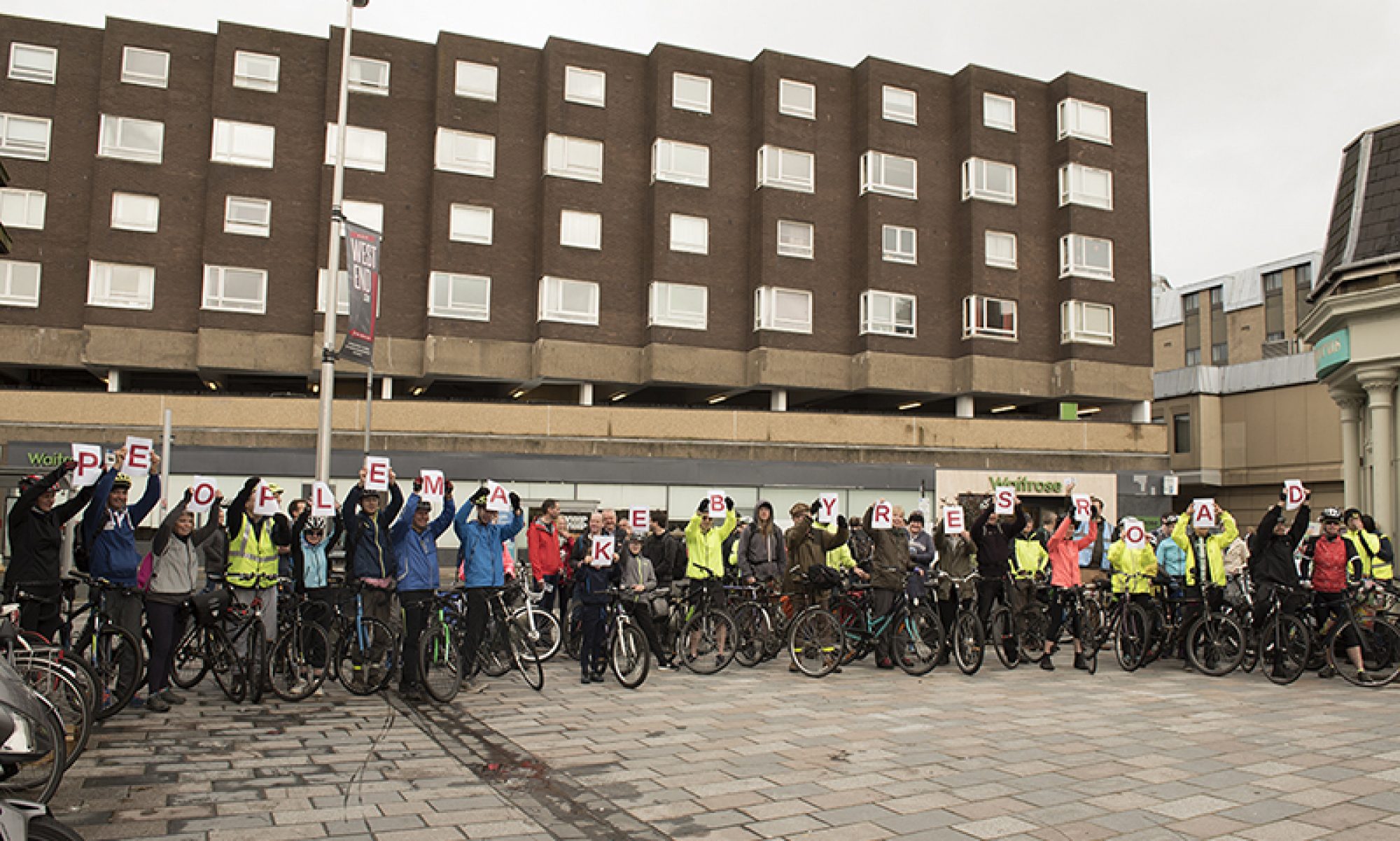
3.1: Glasgow City Council – Spaces for People: Dennistoun Area – Low Traffic Neighbourhood (Temporary Traffic Regulation Order)
This is a follow up from the recent GoBike blog about changes in Dennistoun, which quoted this Temporary TRO (as it came in too late to make the last Digest). The order covers the area between Alexandra Parade and Duke St, known locally as The Drives (from the names of most of its east-west streets – Circus Dr, Roslea Dr, etc).

The above is where your editor has lived for about 15 years and was involved in a plan to reduce ‘through’ traffic in The Drives in 2019, along with Michael from Spaces for People Dennistoun (before Sustrans nicked that name). That plan was a grassroots response to all the 1-way streets in GCC’s earlier Restricted Parking Zone (RPZ) plan for Dennistoun and Royston. Which in turn followed concerns about more parking being displaced into Dennistoun by the Celtic Park/Emirates Event Day Parking Zone plans. There’s also a history of other parking issues, including around Glasgow Royal Infirmary and the City Park building plus commuters using the area as a ‘park and ride’ to the city centre. Many streets in the Drives have the familiar rows of parked cars down both sides, reducing the road width and visibility.
The parking plans have been shelved since all the Roads staff in GCC were redeployed to the Sustrans-funded Spaces for People program. This probably explains the similarities between some 1-ways in the RPZ plan and the new Dennistoun Spaces for People measures.
It may also explain the use of 1-way streets to re-route ‘through’ traffic. Many active travel advocates would expect an LTN to stop rat running altogether. The Sustrans definition of a Low Traffic Neighbourhood is:
“…a scheme where motor vehicle traffic in residential streets is greatly reduced. This is done by minimising the amount of traffic that comes from vehicles using the streets to get to another destination. This is often referred to as ‘through-traffic’ or ‘rat-running’.
Private motorised vehicles still have easy access to all homes and businesses without driving directly through the neighbourhood.
This opens up networks of streets so people can safely travel through the area on foot, bicycle, by wheeling or by bus. Emergency vehicles can also be prioritised to reach their destinations quicker.
Traffic is reduced by using temporary or permanent barriers called “modal filters”. These can include putting up bollards or planters. Or they can be camera operated. Residents and businesses still have access to the neighbourhood by motor vehicle using different routes, but through-traffic is greatly reduced.”
Glasgow City Council’s TTRO contains the grand total of one modal filter (on Ark Lane). In your editor’s opinion, this is four filters short of an LTN. Stopping drivers taking shortcuts through the area would cut down traffic to just residents and deliveries. Allowing it through spreads traffic around the neighbourhood without properly calming the streets. Also, some drivers don’t follow established ‘No Entry’ signs let alone new ones.

(image: Thomas Cornwallis)
The most eye-catching parts of the scheme are probably the extended pavement sections outside Alexandra Parade and St Denis’s primary schools. A row of planter boxes in the road will stop car parking around the school gates on Armadale St and Meadowpark St. This should improve road safety for schoolchildren. Outside the barriers, a painted cycle contraflow lane will go next to the existing road lane. Elsewhere the 1-way sections will allow contraflow cycling but without any marked lanes; just signage.
The rest of the order is mostly about short 1-way sections and double yellow lines near schools and nurseries. However, it also extends lines further on Ark Lane and Broomfield Drive than on the original drawing. There was no explanation but an educated guess is it might be to let bin lorries turn.
Like other SfP projects, the council used emergency powers so they didn’t have to consult local people (they may count Glasgow’s Spaces for People Commonplace map as consultation). This created a lot of confusion around the plans. The reaction online saw some support on Twitter but a lot of negative posts on Facebook. Many complained about loss of car parking and lack of consultation. The council’s ‘map’ (really a technical drawing) didn’t help so your editor produced a new map instead.

Work on signage, barriers, etc. was supposed to be finished before Christmas (but seems to be behind schedule). The temporary trial will last about three months. It remains to be seen how people in cars and on bikes will react to the new cycle contraflows. However, it is a first step towards making the Drives a better place to walk and cycle (if a faltering one). Time will tell if GCC’s scheme brings the benefits recorded in many London LTNs.
3.2: Glasgow City Council – Lourdes Primary School, Glasgow (Temporary Traffic Regulation) Order 2020
Following on from the permanent orders, above, is this Temporary TRO for Lourdes Primary School in the Cardonald area. It seems to add double yellow lines to part of the entrance road to the school (after the roundabout). That’s about it, really.
3.3: NHS Lanarkshire – New Monklands Hospital, preferred site

The latest part of the process to choose a new hospital site was mentioned in Digest 71. A GoBike response in the next Digest was in favour of the Wester Moffat site for active travel.
On 16th December, Lanarkshire NHS Board approved Wester Moffat as its preferred site.
A hospital being built at Wester Moffat brings a lot of potential for improvements to NCN75. The site is just east of Airdrie between the current Wester Moffat community hospital (off Towers Rd) and Easter Moffat golf course. NCN75 is currently on the busy A89 past the site. The off-road route following the Airdrie-Bathgate rail line begins near Caldercruix. If a new off-road path could link Drumgelloch station to the new hospital and Caldercruix it would greatly improve safety and encourage more people to cycle to work, appointments or visiting.
The new East Airdrie Link Road is due to cut through the site (north-south) and was much more of a factor than cycling. However, the Fairer Scotland Duty report, which GoBike referenced, was mentioned a lot in the Board meeting. The new hospital could help regeneration in nearby neighbourhoods like Craigneuk and villages like Plains.
The Cabinet Secretary for Health, Jeane Freeman, has the final decision. Even if it’s approved, it will be several years before the hospital and any new transport links are built.
3.4: Multiplex/University of Glasgow – Campus Development, November 2020 Newsletter
Another few pages of updates in the December 2020 Newsletter. If nothing else, the newsletter helps identify Uni buildings that you’ve seen but never knew what they were called. This month it’s the Pontecorvo building, the Brutalist concrete tower on the corner of Church St and Dumbarton Rd. If you don’t like it, don’t worry; it’s about to be demolished!
Talking of seeing the back of things, this is the last 2020 Digest. This year’s horrendous circumstances obviously overshadow everything. However, the Spaces for People programme created around 10km of ‘soft segregated’ cycle lanes in Glasgow. These have offered protection to hundreds of new Nextbike users and thousands of people who returned to cycling in and around the city.
If you’re wondering where to ride in Glasgow over the festive period, why not try out some of the above on Andy’s three infrastructure routes?
Take care and hope you can still have a Merry Christmas and a Guid New Year.