
Coming back after summer holidays, for some of us, may involve leaving Glasgow Central station onto Gordon St. The scene you’re met with can vary from ‘hustle and bustle’ to a full-on three ring circus of buses, taxis, bikes, people and luggage coming from all angles. There’s a lot of conflict on the block of Gordon St at the station entrance, so it’s ripe for reorganisation. However, the current ‘public realm’ proposals leave a lot to be desired, especially for cycling.
GoBike thinks the changes exclude cycling. We need your help to respond and spread the word about the Gordon St SmartSurvey (consultation deadline: Sunday 24 August). In this article we explain the issues…
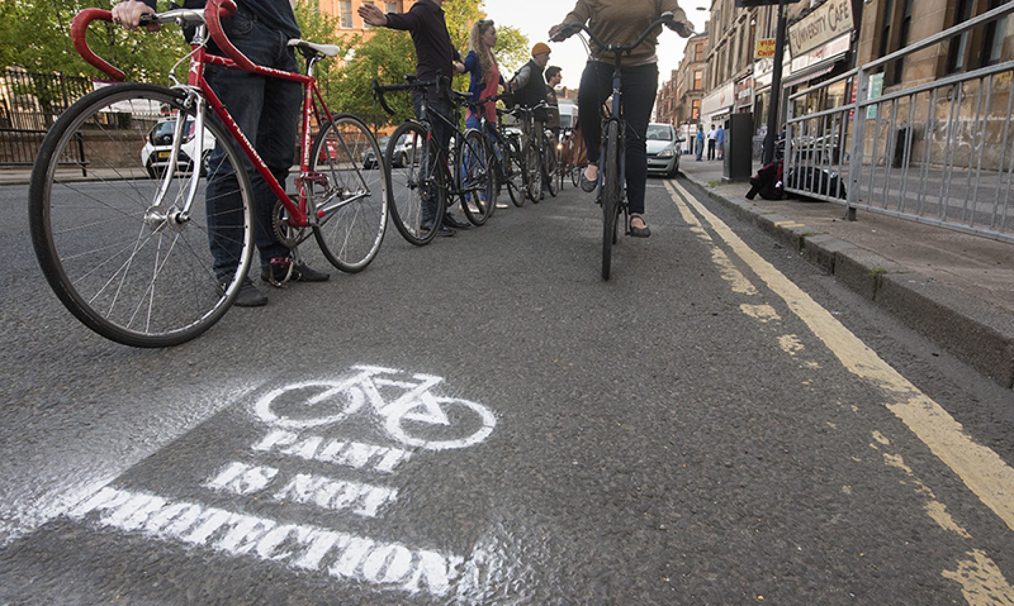
Glasgow Central is the busiest station in Scotland with nearly 25 million pedestrian entrances and exits annually (April 2023 – March 2024). While it has entrances on all sides, the majority of footfall goes through the northern Gordon St entrance. That short section of road also contains a black cab rank, drop-off in-shots, bus stop (under the canopy!) and a (very faded) painted cycle lane.

Council proposals – pedestrians, taxis and buses

The main proposed change is to make the block one way, eastbound only. The black cab rank is staying and the bus stop will be moved to the east of it (was under the canopy). The space under the canopy becomes officially pedestrian-only (it often feels like it is already until a bus drives in!). This change may be spurred by Boots moving into the Gordon St shop unit (formerly used by the ticket office/First Class lounge).

Proposals include several large benches and concrete planters to add greenery. A few seats near the entrance would be useful for people waiting for taxis. However, there seem to be several large units with seats on all sides in a street most people wouldn’t choose to hang out on, due to the risk of anti-social behaviour. These seem to take up a lot of space, possibly to be robust enough to meet the council’s obligations for Hostile Vehicle Mitigation (to guard the station entrance against a terrorist attack). However, HVM bollards, like those near the Scottish Parliament, would do the same job in much less space.

Council proposals – cycling
The obvious question with a one-way street is ‘will there be a contraflow cycle lane?’ Frustratingly, the answer seems to be ‘no’. That’s despite the clear precedent on the block to the east (with a cycle-only light already installed). Also, the temporary layout outside Central itself during Covid-19.

Even worse is the fact an eastbound-only road would cut off access to the southbound contraflow lane on Hope St to the West City Way (and the Nextbike station). Early correspondence from GoBike to GCC and survey responses by members focussed on these issues.

Council response
The response we got from Glasgow City Council included some statistics and a new map with an alternative westbound route. These seem to be new proposals for protected lanes on St Vincent St and Wellington St, separate to previous Avenues plans. If so, that’s appreciated but the current plans for Avenues stop at Buchanan St and the proposed route seems to start a block later at W Nile St. Also, it goes uphill after Hope St and bypasses the station altogether!
Going north on W Nile St seems to be the suggested way to get to the new route (rather than hazardous George Sq or pedestrian-heavy Buchanan St). However, this still takes you out of your way through seven sets of traffic lights (versus one at Gordon St/Union St). This is supposed to be a route to a railway station so people can actually catch their train!

Also, this means the Hope St contraflow lane being changed to northbound (with changed signals at Gordon St). The map mixes current and future routes so it’s not clear what’s being kept, but the survey page doesn’t show any cycle lane. The changes and installing the new lanes would cost much more than a lane on Gordon St.
Why are GCC offering a longer, more expensive alternative for cycling but not any other mode of transport? The council’s justification is the figures in graphs produced from CCTV with automated counters. It’s not clear how accurate these are when most people would walk their bike in and out of the entrance. As above, Central’s main entrance is one of the busiest places in the country for pedestrians.


At the western end of Gordon St, there’s the Hope St segregated contraflow lane (and a Nextbike station). That lane goes past the side entrance of Central Station then turns to the West City Way on Waterloo St, which continues to the Connect2 bridge over the M8 and beyond. So, most people cycling from the West End to Central would use the Hope St entrance (not Gordon St).
Cycling infrastructure to the east is patchy to non-existent. Gordon Street’s faded cycle lane leads on from a painted contraflow lane (between Union St and Mitchell St). It’s to the west of the pedestrianised part of Gordon St (off Buchanan St). Coming from Dennistoun or Royston there are hellish junctions at Castle St towards Cathedral St. The few (slightly) quieter streets like Bell St or Havannah St give way to main roads like Ingram St (before you can cut through Royal Exchange Sq and across Buchanan St). There’s a patchy protected route from Calton via London Rd/St Andrews Square but it heads south of the station (so isn’t much use if you’re going for a High Level train). On Duke St, the Avenues Plus protected route that’s under construction should help. However, it still won’t connect to George St/George Square or Gordon St. The above goes some way to explain the cycling figures.
Regardless, GCC, ScotRail, SPT and others have made commitments to support active/sustainable travel, which includes increasing cycling modal share. You don’t do that by disadvantaging cycling compared to all other modes. It’s frustrating that, just as ScotRail have improved bike spaces and markings on trains, there are moves to make it harder to cycle to the busiest station in Scotland. There’s a national transport hierarchy with cycling second after pedestrians and before public transport and private cars. That clearly isn’t being followed in the Gordon St plans.
Rail and cycling should be a natural combination – take the train for longer distances and bike for the last few miles. This is well understood in places like Belgium and the Netherlands, where cycle-train commuters are studied as a separate category. The Dutch are known for high quality infrastructure like protected routes and huge cycle parking garages at their main train stations. In future, as routes like Argyle St develop, Network Rail could use empty shopfronts on Argyle St/Hielenman’s Umbrella, which back into Glasgow Central, or the road ramp on Hope St to create new bike parking for people who don’t/can’t take their bike on the train. In the meantime, they should still support direct routes for people who want to take their bike with them (to both High and Low Level platforms).
Potential solution

The simpler, cheaper, more direct solution to the issue would be to put a westbound contraflow cycle lane on the revised Gordon St. It would preserve links to existing infrastructure (instead of forcing a confusing reorganisation). Since there would be no need for a westbound lane on the road the pavement could be extended, even with a westbound bike lane. Getting smaller planters and seating and arranging them with a gap to a new row of bollards would leave space for a contraflow lane. Since the eastern parking in-shot is being removed (a one-way lane only needs about 2m). It’s more open at the western side (where the fireman statue is set back from the corner).
If the alternative route links with other Avenues plans then it could still be useful in future. But, for getting to a train on time, Gordon St is still the best option.
Consultation links
See: GCC Gordon St article and Gordon St SmartSurvey. The survey has half a dozen short pages (or more depending on answers to questions) but most of the questions are optional. If you want, you can skip to comment boxes to raise the issues we mentioned, above.
Consultation deadline: Sunday 24 August 2025.