
Consultations in Glasgow, including a short notice event. Also, consultations from North Lanarkshire, South Lanarkshire, SPT and an update from East Dunbartonshire.
East Dunbartonshire
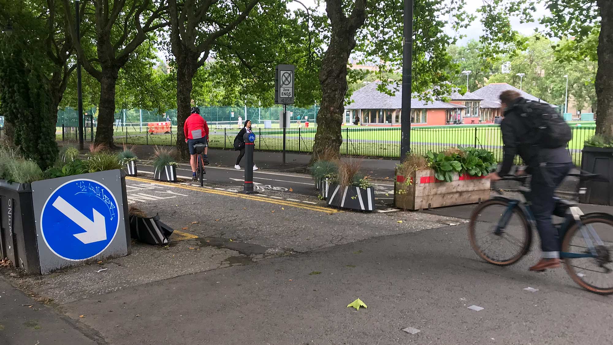
Westerhill Development Road
(Bishopbriggs Relief Road)
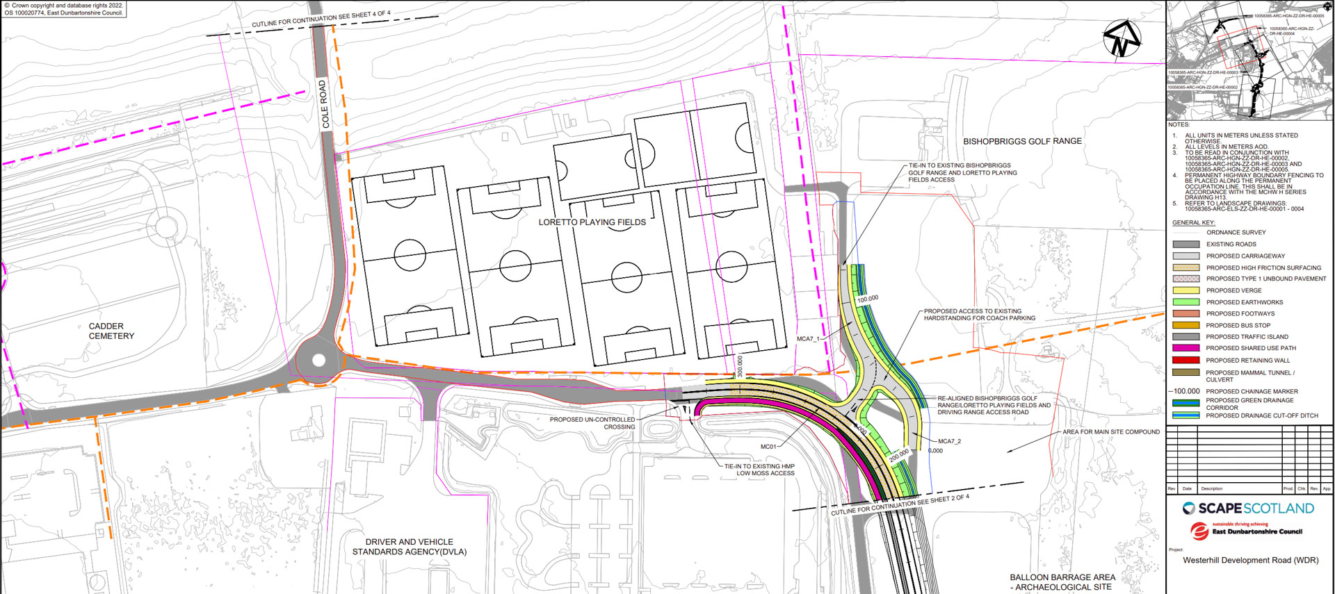
Feedback that this new road has been given planning permission. Back in 2024 (Digest 151), the route was chosen to extend the current Westerhill Road north past Low Moss prison. It would then join Kirkintilloch Rd (A803 – between Cadder/The Stables pub). EDC say it will include a “new active travel route for walking, wheeling and cycling.” In the ‘General arrangement’ layout, this seems to be a shared pavement continuing from the crossing at the northern end of the Wester Way (near the former Aviva office building). Unfortunately, since some parts (like Cole Rd) aren’t being upgraded, the AT route stops near Loretto playing fields. A dashed orange line indicates ‘Masterplan Future Active Travel route’. That may refer to the ‘Primary Active Travel route’ in a previous Planning Guidance document (see Digest 157). There’s no detail on why it’s not being built along with the road. Also, it’s not clear why a redundant section of Crosshill Rd will be used for “mosaic habitat” instead of cycling?
Links: East Dunbartonshire Council WDR article and Planning application TP/ED/25/0151.
Glasgow City
North Laurieston masterplan – Stage 2

A further consultation following the Stage 1 event (June update). The project website has summaries and survey results to feed into Stage 2. ‘Connected cycle routes’ was ranked third in their Movement strategy survey. The masterplan area on the south bank of the Clyde includes Carlton Place, South Portland St (Avenues project) and the South City Way on Gorbals St (past the Sheriff Court and Central Mosque).
Event: Wednesday 12 November, 2pm–8pm at the former Savings Bank, 67 Bridge St, Glasgow G5 9JB (presentation at 6.30pm).
Links: North Laurieston microsite (sideways scrolling).
Improving Drumchapel Town Centre

Glasgow City Council say: “As part of the plans to improve Drumchapel town centre, we want your views on how best to change the roads layout of Kinfauns Drive from Hecla Ave down to Duntreath Ave, to make it easier to get around the area and make it more attractive.” The visuals show the curving raised platform has gone from the northern corner of Kinfauns Dr. Further south, the biggest change in the plans is removing the Drumchapel Roundabout. A (two-stage) crossing will be added on Duntreath Ave with an interesting junction at Aldi. There seems to be a wide verge on the western side of Duntreath Ave but sadly no segregated cycling route there or on Kinfauns Dr. There’s definitely cycling in the area as Drumchapel Cycle Hub are based just along from the junction on Drumry Road East.
Links: Drumchapel Town Centre survey.
Deadline: Monday 15 December 2025.
Thornwood Roundabout and NCN7 Project

A long overdue project for active travel improvements around Thornwood Roundabout and National Cycle Network Route 7 (NCN7). The roundabout plans are for new crossings and pavements/shared paths (widened onto verges). Crossings at north and east are 2-stage but close to ‘desire line’, with a few pinch points at corners. Crossings at west and south are set much further back (on existing paths). Sawmill St has a shared path south to crossings to a bi-directional cycletrack on South St/Castlebank St. That protected route runs most of the way to Pointhouse Place where there’s a shared path from the corner at the Riverside Museum. There’s a useful fly-through video of the route on the council webpage (and many visuals, which show cyclists riding on the right!). The cycletrack continues west along South St to the crossing at the end of the old railway path on the north side (near Dilwara Ave). While Thornwood roundabout is still car-dominated the plans are an upgrade for active travel. The cycletrack would be a very welcome improvement compared to NCN7’s current shared pavement.
Links: Thornwood-NCN7 consultation, Thornwood-NCN7 survey, Thornwood roundabout plans (PDF) and NCN7 plans (PDF).
Deadline: Sunday 17 December 2025.
North Lanarkshire
Bellshill to Mossend Active Travel
(Eurocentral Active Travel links project)

North Lanarkshire Council say: “The project is funded by NLC through the Glasgow City Region Deal which provides for infrastructure projects that connect people with employment opportunities. Three of the five routes are already at the detailed design stage, while the remaining two are at the concept design stage.” The latter runs through Bellshill town centre. The preferred route uses mostly back streets (John St and an awkward junction onto Dean St). Alternatives in the consultation include a route on Main St (which has a high school and very wide pavements in places). As it goes east, the route uses main roads through Mossend and Holytown towards EuroCentral (A755 corridor). North Lanarkshire favour widened pavements over on-road protected lanes so it’s likely this route will follow the pattern set in Motherwell (Muir St), Wishaw (Alexander St) and elsewhere.
Links: Eurocentral Active Travel Links StoryMap, Bellshill–Eurocentral survey
Deadline: 30 November 2025.
South Lanarkshire
Draft Transport Strategy Consultation 2025 – 2035

South Lanarkshire Council say: “This survey follows on from the first round of engagement undertaken in 2023 and subsequent work to develop South Lanarkshire’s next Local Transport Strategy (LTS), which will cover the period 2025 to 2035. This consultation will inform the finalisation of the Local Transport Strategy for adoption at the end of this year.”
SLC Local Transport Strategy on cycling: “…it is recognised that further investment is crucial to achieve the level of change required to meet climate targets, tackle poor health and address social exclusion. South Lanarkshire Council will further extend the active travel network during the lifetime of this LTS, including the provision of supporting infrastructure.” There’s very little further detail (similar to the recent South Lanarkshire Cycling Partnership meeting, which failed to mention this consultation!).
Links: Draft Local Transport Strategy document, LTS consultation page and LTS survey.
Deadline: 9 December 2025.
SPT
Buchanan Bus Station Masterplan

Radical redevelopment proposals for the bus station. The current building and neighbouring multi-storey car park would be demolished. Only the Gallery Apartments/Sainsbury’s building would be kept. The rest of the block would be used for the new bus station and housing/student flats. The curved layout seems to have fewer stances than the current bus station. The bridges from Cowcaddens Rd may deal with the level difference but could raise issues of anti-social behaviour (on the buses below). On three sides will be Avenues cycle lanes (Cowcaddens St/N Hanover St/W Nile St). No obvious details about bike parking in plans.
Links: Buchanan Bus Station Masterplan webpage and BBS online survey.
Deadline: “before 23 November”.