

Here’s a list of consultations going on in Glasgow and around Strathclyde (and one we missed…).
Argyll & Bute
Tarbert Ferry Terminal to Whitehouse – Community Path
Continuing consultation on a path between Tarbert’s ferry terminal, on Loch Fyne, across the top of the Kintyre peninsula to Kennacraig ferry terminal/Whitehouse. Stage 2 consultation (Stage 1 was in 2024) with concept designs for the route alongside the A83. An in-person consultation event in Tarbert has passed. This path to the south-west seems to be separate from the north-east path project (Tarbet to Inverarnan).
Links: Tarbert to Whitehouse Community Path (Engagement Hub), large plan image (ZoomHub), Tarbert–Whitehouse survey, Feedback Map and ABC website page.
Deadline: Tuesday 30 September 2025 (17.00).
East Renfrewshire
Barrhead Road Active Corridor (Newton Mearns)

Updated plans for the third phase of this route on Barrhead Road in Newton Mearns (phase 1 is still under construction on Aurs Road at Balgray Reservoir). This will be an important active travel link across the M77 motorway between Newton Mearns town centre and greenspace at the reservoir. “Barrhead Rd would include improved paths and crossings; priority for people walking, wheeling, and cycling at junctions; traffic calming measures; improved road crossings; and new signage.”
Drop-in event with the project team: Mearns Library on Wednesday 1 October from 3-7pm.
Links: Barrhead Rd Active Corridor page
Deadline: 26 October 2025.
Glasgow City
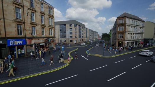
Avenues Plus Duke St/John Knox St
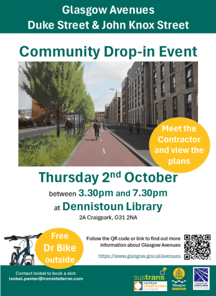
A ‘meet the contractor’ event for the Avenues Plus routes currently under construction on Duke St (and planned for John Knox St). Apparently, an “opportunity to view the plans, ask questions, and meet the contractor’s team from Rainton Construction”. Perhaps also to ask about potential links to the new Avenue on Ark Lane and Westercraigs (which could lead directly into the Drives if it had a contraflow bike lane)? Also, Bike for Good will have a Dr Bike (maintenance/servicing) session outside from 4.30 to 6.30pm.
Drop-in event at Dennistoun Library on Thursday 2 October 2025, 3.30 to 7.30pm.
In other Dennistoun news, a Traffic Regulation Order for parking controls is due out shortly.
Connecting Yorkhill and Kelvingrove – Phase 4

“Proposals include an enhanced public realm outside Exhibition Centre Train Station, with plans aiming to create a more inviting and accessible space that supports sustainable travel. This project also explores how Corunna Street, Minerva Street and St Vincent Crescent could be improved to better support walking, wheeling and cycling, while creating more welcoming and accessible public spaces. Proposed improvements include making Corunna Street one-way northbound with a dedicated southbound cycle lane, upgrading pavements and crossings, and adding clearer signage to improve wayfinding.”
Links: Connecting Yorkhill–Kelvingrove Smartsurvey.
Deadline: 7 November 2025.
Yorkhill to Anderston Liveable Neighbourhood – Phase 1
“Plans for the Anderston Liveable Neighbourhood build on earlier community feedback, and focus on improving the environment for pedestrians at Kent Road, Brechin Street, Claremont Street, Breadalbane Street and Dover Street. Proposed changes include upgrading pavements with dropped kerbs and tactile paving, improving pedestrian crossings, and adding new infrastructure such as cycle shelters, green planting and enhanced drainage.”
Links: Yorkhill–Anderston LN Smartsurvey.
Deadline: 7 November 2025.
Townhead Greening and Connectivity event

Apologies that we missed this local event in Townhead in the run-up to our AGM. It was about the open spaces in the neighbourhood bordered by the new Avenues under construction on N Hanover St and Kyle St.
North Ayrshire
Maritime Mile, Irvine

This is a large development programme to improve Irvine’s harbour area. “Phase 2 will improve the layout and appearance of Harbour Street and Montgomery Street and connections between Irvine Railway Station and the Beach Park. Activity hubs and spaces will also be created providing new opportunities to enjoy the Harbourside area.” Most of the plans appear to be shared use paths.
Drop-in events:
Wed 8 October, 12 noon – 3pm: Rivergate Shopping Centre;
Wed 8 October, 5pm – 7pm: Fullarton Connexions.
Links: Maritime Mile page, proposals and survey.
Deadline: Sunday 12 October 2025.
North Lanarkshire
East Airdrie Link Road

Major changes for Stage 3 of EALR – a new access road added to the new hospital from Towers Rd. Pavements were previously dropped from the main EALR trunk road between Riggend and Newhouse. The new road, next to a school, and wider road safety measures gives an opportunity to push for better active travel provision to the hospital from both Airdrie and the village of Plains. NCN 75 passes through both places and next to Drumgelloch train station. It’s important NLC also retain existing plans for an active travel path/bridge between the hospital and station.
Links: EALR consultation page, EALR StoryMap.
Deadline: Sunday 26 October 2025.
South Lanarkshire
Coalburn path openings
No new consultations but a follow-up on previous Douglas Valley consultation and Active Travel studies of Clydesdale. Two new active travel paths recently opened around Coalburn, on NCN74 in rural South Lanarkshire, with a further path to follow between Coalburn and Douglas. Coalburn Community Action Group campaigned for the path project, which was managed by Community Action Lanarkshire.
Being close to wind farms and potential for tourism seem to have helped with funding, according to SLC’s South Lanarkshire View:
“Construction funding was provided by South Lanarkshire Scotland Renewable Energy Fund (REF) via OnPath Middlemuir Windfarm and Walking Scotland’s Ian Findlay Path Fund.… …The work is part of a larger initiative to enhance the recreational and tourism offer, which includes the development of a Douglas Valley focussed Outdoor Recreation and Adventure Tourism scope, progressed by the Douglas Valley Advisory Group.”
Links: Coalburn to Poneil active travel path and Coalburn to Lesmahagow active travel path.