
Being prAGMatic?
The heat is on in June with tight deadlines and tight spaces in South Lanarkshire and Argyll & Bute. Also, updates from North Ayrshire and North Lanarkshire.
As the Argyle Street West TRO closes, an Avenues Plus consultation is due to open in the East End.
It’s also an important time for GoBike with our AGM on Saturday 3 June (World Bicycle Day!), our monthly ride on Sunday 4 June and then the Accessible and Inclusive Design Forum on the Monday.
Forthcoming events
Glasgow Avenues Plus – Duke Street & John Knox Street, Community Drop-in Event:
Thursday 15 June 2023 at Dennistoun Library, 2pm–6.30pm (and on-street along route).
An online questionnaire will go live on 15 June (on Ironside Farrar’s consultation website).
See further information in this Dennistoun Community Council article.
Contents
(new consultations in bold)
1: Current Consultations
- East Kilbride Town Centre Active Travel Network – Phase 1.4
- Dunoon to Hunters Quay Active Travel Route
- Irvine housing developments – Revised draft plans
- Argyle St West (Traffic Regulation Order)
- North Ayrshire Local Development Plan 3
- North Lanarkshire Council – Green and open space survey
- Loch Lomond & the Trossachs National Park Partnership Plan
- Devon Street Urban Park
2: Consultation Feedback
3: Proposed Traffic Regulation Orders
Section 1: Current Consultations
(in date order for responses)
1.1: East Kilbride Town Centre Active Travel Network – Phase 1.4
Council: South Lanarkshire.
Area: West Mains Road at its eastern end, from Creighton Grove to the Priestknowe (Three Bears) roundabout.
Subject: Section of W Mains Rd past housing to link to bike paths on Churchill Ave. There are two options to continue east of the existing 1-way cycletracks (from zebra crossing). Option 1 has a short 2-way cycletrack then shared path, with green space made into a ‘pocket park’ (keeping most parking bays). Option 2 is mostly 2-way cycletrack, except for short breaks at disabled parking bays, then shared path round corner at roundabout. The latter would remove most of the current car parking spaces and convert the grass area into a residents car park. While the council have to keep residents on-side, it’s a bit of a Hobson’s choice between the two options. Also, SLC haven’t addressed links from Creighton Grove up to Hunter Community Health Centre and Andrew St, which need resurfacing/re-signed.
Featured: Digest 110, 2.3.
Website links: East Kilbride Town Centre Active Travel Network – Phase 1.4 webpage.
Deadline: 2 June 2023.
1.2: Dunoon to Hunters Quay Active Travel Route

Council: Argyll & Bute.
Area: Coast north from Dunoon ferry terminal to Hunter’s Quay ferry terminal.
Subject: A rare appearance by A&BC with an active travel route to link two ports. Consultants Stantec say: “The proposed active travel route was subject to engagement work in 2018-2019 and is now being revisited due to a change in national cycle design standards. Draft concept designs will be produced for the entire route. Due to the limited street space on the section of route between James Street and Hunters Quay Ferry Terminal, three potential options are presented for further consideration prior to developing designs.” The impact of new standards is shown in option 2 for Hunter’s Quay – potentially repositioning a sea wall!
Website links: Dunoon to Hunters Quay Active Travel consultation.
Deadline: 6 June 2023.
1.3: Irvine housing developments – Revised draft plans

Council: North Ayrshire.
Subject: Two sites are being redeveloped – part of Ayrshire Central Hospital’s grounds and Montgomerie Park in Irvine, either side of the A78. Both housing plans include accessible homes and walking/cycling links. Montgomerie Park seems to include a cycle path alongside the site, which links to an existing off-road path, but there isn’t much detail on width or design. Each development is due to have an in-person consultation event:
Ayrshire Central Hospital – 6 June 2023, 4pm–6pm at Castlepark Community Centre.
Montgomerie Park – 13 June 2023, 4pm–6pm at Lanfine Community Centre.
Featured: Digest 120, 1.6.
Website links: Ayrshire Central Hospital revised draft plans and Montgomerie Park consultation revised draft plans.
Deadline: 16 June 2023.
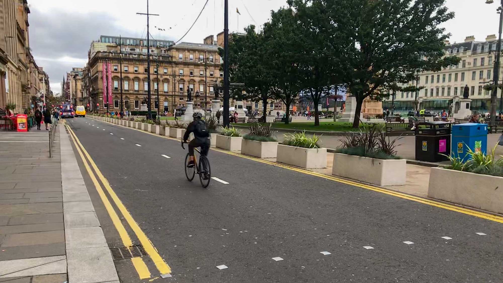
1.4: Argyle St West (Traffic Regulation Order)
Council: Glasgow City.
Subject: The public (Stage 2) TRO is out for this Avenues project. GoBike wrote to the council about the plans at Stage 1 (consultees only). GCC’s reply went into some technical details. The project was on hold during the pandemic so designs date from before the update of Cycling by Design (2021). Existing roadspace becomes one-way cycle lane weaved around car parking bays. We’ve previously heard that the shallow Argyle St rail tunnel dictates where ‘rain gardens’ can go. Apparently, that’s why the plans have planting nearer buildings and the cycle lane at the kerb. However, the zigzag bike lanes will be seen as Glasgow’s answer to the notorious lanes on Leith Walk, Edinburgh. Western Argyle St may not be as busy but large developments west of the M8 will soon increase footfall. The order also covers the ‘Hielenman’s umbrella’ and one-ways on Albion St/Shuttle St (Merchant City).
Featured: Digest 101, 2.2.
Website links: GCC Proposed TROs, Argyle St West TRO documents.
Deadline: 19 June 2023 (typo in original date, it was 9th – apologies).
1.5: North Ayrshire Local Development Plan 3
Council: North Ayrshire.
Subject: First consultation stage for the next Local Development Plan by North Ayrshire. It may be one of the first in Scotland under the new National Planning Framework 4 (NPF4 came into force in February 2023). As a result, it should have more emphasis on the environment, including active travel. Getting cycling routes/networks, developer obligations, etc. mentioned in the LDP makes them more likely to be delivered. Also, if developers proposals miss out or go against the LDP, these give people grounds to object and have plans altered or conditions added.
Website links: North Ayrshire LDP3 consultation website.
Deadline: June 28 2023.
1.6: North Lanarkshire Council – Green and open space survey
Council: North Lanarkshire.
Subject: Survey and audit data to feed into an Open Space Strategy and other policies. NLC avoid on-street protected cycle lanes, so anything affecting off-street paths could have a big impact on cycling in the county. Areas like the Seven Lochs Wetland Park have cross-border active travel routes (Hogganfield Loch to Drumpellier Country Park, Coatbridge). NL’s other country parks, Palacerigg (see above) and especially Strathclyde Park, are also havens for active travel. The latter has added and upgraded paths near Bellshill with more of NCN74 due to be re-routed through the park. The council ignored a GoBike suggestion for links between Strathclyde Park, Duchess Park, Ravenscraig and the existing Greenlink route (as part of redevelopment of Airbles Rd). There’s potential for similar links around some of North Lanarkshire’s dozen nature reserves. The consultation has a general survey and one about specific places that are important to visitors or residents.
Website links: Green and open space surveys.
Deadline: 10 July 2023.
1.7: Loch Lomond & the Trossachs National Park Partnership Plan
Organisation: Loch Lomond & the Trossachs National Park.
Area: The park ranges from Loch Eck and Loch Goil in the west to Loch Earn and Callander in the east. Also, from Killin and Crianlarich in the north to Balloch in the south (but it misses out Helensburgh and Gare Loch).
Subject: A wide-ranging five year plan for the park. It includes a section on ‘Low Carbon Travel for Everyone’. Cycle routes and active travel are mentioned briefly but most of the section is about buses. That may make sense, considering the size of the park, but it’s still a bit disappointing. There’s already a cycle route from Balloch up the west side of Loch Lomond (and there were plans for an active travel route to Inverarnan as part of A82 works). Active travel paths were extended along the River Goil in 2021 and there seems to be plenty of scope for more.
Website links: Loch Lomond & the Trossachs National Park Commonplace site.
Deadline: 19 July 2023.
1.8: Devon Street Urban Park
Organisation: Glasgow Urban Sports (GUS).
Area: Southside between Eglinton St and Pollokshaws Rd.
Subject: Formerly GUS M74, now revised and renamed… “The Devon Street Urban Park project is a proposal from Glasgow Urban Sports (GUS), a community led organisation, that aims to transform an unused area of land under the canopy of the M74 motorway, on the southside of Glasgow, to create a new public urban park and community leisure space.” While the project still involves building a skatepark it seems to have broadened out a bit to gain more community support. There are new partner organisations on board and a new survey to fill in.
Featured: Digest 92, Item 1.14.
Website links: Devon St survey, new GUS website.
Deadline: No obvious deadline.
Section 2: Consultation Feedback
2.1: City Network – Delivery Plan (Phases 4 & 5)


Subject: An important report from the council about how the City Network will be delivered. The main headline is the phasing and distances planned. Phases 0–3 were covered in previous Digests. No exact timescales were given except that whole network is intended to be complete within ten years (or 2030 in some reports).
Phase 4 – Drumchapel–Anniesland (6km), Robroyston (6km), Ruchazie (11km), King’s Park–Carmunnock (14km).
Phase 5 – Anniesland–Partick (6km), Kelvindale (8km), Tollcross–Garrowhill (13km), Nitshill (7km).
The spread of distances in these phases goes from 14km in King’s Park–Carmunnock down to 6km for Anniesland or Robroyston.
The report also says: “While a phasing plan has been developed for the City Network, this has to be regarded as indicative. It is critically important that delivery is flexible and reactive to take advantage of any development and funding opportunities which may emerge. As such, phasing proposals will be regularly reviewed.”
Featured: Digest 134, 2.1, Digest 135, 2.1.
Website links: City Network – Delivery Plan report.
2.2: Muir Street, Motherwell – Transport facilities open

Subject: North Lanarkshire Council sent the following:
“Work on the new transport hub at Muir Street in Motherwell is now complete.
The expanded bus stop next to Motherwell Rail Station is open, with a refurbished shelter and space for four buses. Real time information signs will be installed soon.
A new access road and path runs between Hamilton Road and the station, with a rank for eight taxis, parking for blue badge holders, and drop off spaces has opened. The feeder taxi rank on High Road is also still available. Cycle parking is available in front of the station. Scotrail’s improvement work at Motherwell train station will be complete by the end of June. The transport hub project is being funded jointly by Transport Scotland, SPT, North Lanarkshire Council, through the Glasgow City Region City Deal, and ScotRail.”
It’s good to see the new facilities finally finished (original date was summer 2022).
Featured: Digest 92, 3.1.
Website links: North Lanarkshire Council, Muir Street page.
Section 3: Proposed Traffic Regulation Orders
3.1: East Dunbartonshire TROs

Areas: Bishopbriggs.
Subject: A TRO about parking named ‘Thrums & Ochil’ (for Linnhe Ave, Ochil Rd and Thrums Ave, Bishopbriggs). Made on 24 April to take effect on 12 June 2023.
Website links: East Dunbartonshire TROs.
3.2: Glasgow City TROs and Traffic Calming
Subject: See Argyle St West, above. There’s also a parking TRO for Springhill Parkway (and Springcroft Road), Baillieston – near Easterhouse train station.
Website links: Glasgow City Proposed TROs and Glasgow City Proposed Traffic Calming Schemes.
3.3: North Lanarkshire TROs
Areas: Towns and villages throughout the county.
Subject: Part-time 20 miles per hour speed restrictions – many around schools. Various Roads (Central region) covers Airdrie, Bellshill, Calderbank, Caldercruix, Coatbridge, Plains and Tannochside (page says Uddingston). Deadline: 14 June.
Website links: North Lanarkshire Live Consultations.