
Avenues and corridors…
Major changes are proposed for Cowcaddens Rd/Dobbie’s Loan (visual of Port Dundas Rd, above). Another Avenues project on Pitt St has a Traffic Regulation Order, as does the East City Way on London Rd. It’s last call for St George’s Rd but more from Connecting Woodside in Glasgow’s TROs.
East Renfrewshire’s Local Action Plans close soon but Balgray Connections is open a bit longer. East Dunbartonshire have extended one consultation and started a major one about the Springburn Rd/Kirkintilloch Rd ‘corridor’. Also, good news from Inverclyde.
1: Current Consultations
- St George’s Road – Phase 2
- Giffnock Local Action Plan map
- Clarkston Local Action Plan map
- Eaglesham Local Action Plan map
- Lennoxtown Main Street Improvement Project Consultation
- Balgray Connections
- A803 Corridor Improvements Project (Springburn Rd)
- Cowcaddens Road & Dobbie’s Loan (Avenues Plus)
2: Consultation Feedback
- Greenock town centre to Battery Park SfP lane
- Port Glasgow 20mph zone
- Glasgow Uni campus redevelopment – October 2022 newsletter
3: Proposed Traffic Calming/Traffic Regulation Orders
1: Current Consultations
(in date order for responses)
1.1: St George’s Road – Phase 2
Council: Glasgow City.
Area: Part of the wider Connecting Woodside project.
Subject: St George’s Rd, including remodelling the dangerous Charing Cross junction. A 2-way protected cycletrack would run from there alongside the M8 (with two options for the crossing at Phoenix Rd). It then crosses from the south to north side of the road at Clarendon Place, which would be stopped up at its south end (and re-opened at north). The route would continue on the north side of St George’s Rd to meet the protected lane already built at Garscube Rd. Also, it would have new pedestrian crossings at Woodside Library, N Woodside Rd and St George’s in the Fields.
Featured: Digest 121, Item 1.13.
Website links: St George’s Rd consultation (foot of page), storymap and survey.
Deadline: 14 November 2022.
1.2: Giffnock Local Action Plan map
Council: East Renfrewshire.
Subject: Three further consultations on East Ren towns (following the five in Digest 112, June 2022). While each varies in size, all are relatively affluent and suburban areas south of Glasgow. All three have drop-in events but Giffnock’s took place earlier in the month. Giffnock includes Fenwick Rd, which had ‘soft segregation’ on its cycle lanes for a while before the temporary bollards were removed in spring (Digest 107). As well as the A77, a rail line goes through the town with only a handful of crossing points. The map has over 150 comments.
Featured: Digest 121, Item 1.14.
Website links: Giffnock Commonplace map.
Deadline: 14 November 2022.
1.3: Clarkston Local Action Plan map
Council: East Renfrewshire.
Subject: Clarkston’s consultation comes after its neighbour across the White Cart Water, Busby, had its turn in the summer. The southern edge of Clarkston includes Williamwood High School, off Eaglesham Rd (B767), the subject of a current cycle lane petition. The map has over 260 comments.
Featured: Digest 121, Item 1.15 and previous Clarkston consultation.
Website links: Clarkston Commonplace map.
Deadline: 14 November 2022.
1.4: Eaglesham Local Action Plan map
Council: East Renfrewshire.
Subject: While many of East Ren’s towns bleed into each other, Eaglesham is more rural, between Whitelee Wind Farm and East Kilbride, South Lanarkshire. Also, it’s less connected, without a rail line or cycle paths to nearby towns. The map has over 60 comments.
Featured: Digest 121, Item 1.16.
Website links: Eaglesham Commonplace map.
Deadline: 14 November 2022.
1.5: Lennoxtown Main Street Improvement Project Consultation
Council: East Dunbartonshire.
Subject: Lennoxtown is known as the site of Celtic FC’s training complex. Despite being at the foot of the Campsie Hills, its Main St is not as picturesque as its setting. It has had some regeneration, including Lennoxtown Hub, housing the library and health services. Now a previous improvement project from 2019 is restarting – an initial survey is due to lead to refreshed concept designs for the Main St.
Featured: Digest 121, Item 1.7.
Website links: Lennoxtown project page and survey.
Deadline: 20 November 2022 (EXTENDED).
1.6: Balgray Connections
Council: East Renfrewshire.
Area: Balgray reservoir in Dams to Darnley Country Park, between Barrhead and Newton Mearns in East Renfrewshire.
Subject: Active travel paths added to Aurs Rd in Barrhead and Barrhead Rd in Newton Mearns. In Barrhead, it seems to be a ‘Quietway’-style route on Springfield Dr, parallel to Aurs Rd. It would have raised road tables at junctions and toucan crossings at Aurs Rd and Springfield Rd. At the Newton Mearns end, there would be a shared pavement around the M77 bridge and Westacre Roundabout. However, east of a toucan crossing, there would be proper segregated cycle lanes. These should go the rest of the way to Mearns Cross but there’s doubt about the design around bus stops (possibly due to accessibility concerns?). The Aurs Rd re-alignment project is the bit in the middle, due for construction in 2023–24.
Featured: Digest 122, Item 1.12.
Website links: Balgray Connections Commonplace map.
Deadline: 21 November 2022.
1.7: A803 Corridor Improvements Project

Organisations: East Dunbartonshire Council, Glasgow City Council and Strathclyde Partnership for Transport (SPT).
Area: Most of the length of the A803, Springburn Rd/Kirkintilloch Rd. It runs from the M8 through North Glasgow to Bishopbriggs.
Subject: Phase 1 of a joint City Deal project about how to improve the A803 corridor. In Glasgow, it’s a dual carriageway which is a barrier between neighbourhoods. It has some shared paths around it but none are very wide (despite having space on some of its verges). Towards Bishopbriggs it narrows to one lane each way and is a busy main road surrounded by housing, car showrooms and shops. There’s potential to link to existing protected cycle lanes at Hawthorn St and Fountainwell Rd. Also, to nearby train stations at Springburn and at Bishopbriggs. The A803 project will tie in with Bishopbriggs Town Centre Regeneration. The survey is a chance to get protected cycle lanes into the plans.
Drop-in event – Bishopbriggs War Memorial Hall on Tuesday 15 November, 12–6.30pm. Also, the survey is available in Springburn Library, Bishopbriggs Library and Leisuredrome Leisure Centre.
Website links: A803 Corridor Improvements Project – Survey and A803 Stage 1 Consultation Boards (PDF, 71MB).
Deadline: 22 November 2022.
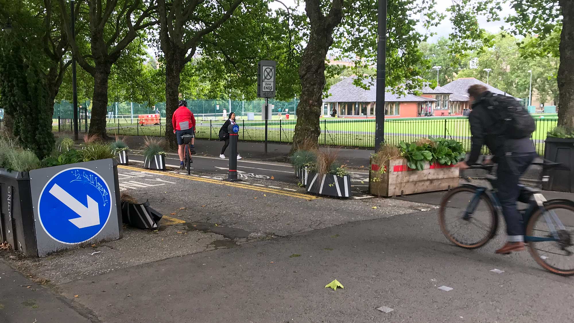
1.8: Cowcaddens Road & Dobbie’s Loan (Avenues Plus)

Council: Glasgow City.
Area: The length of Cowcaddens Rd from Cambridge St to Caledonian Uni. A section of Dobbie’s Loan between N Hanover St and Canal St.
Subject: Part of the Avenues Plus project, which also covers Duke St/John Knox Street and S Portland St (which had a consultation event in May 2022). Cowcaddens Rd and Dobbie’s Loan both link to N Hanover St and have a joint consultation. The plans for Cowcaddens Rd look promising, especially the radical redesign options for the Port Dundas Rd junction (in featured image at top). The Dobbie’s Loan plans also add two-way protected lanes (especially useful for students at Glasgow Caledonian Uni and its nearby halls). However, the lanes stop short of the trunk road junction, which leads under the M8 to Craighall Rd and Port Dundas. The boards include an updated Avenues phasing map (now with Block D added). A very short notice consultation event took place on 31 October.
Website links: Consultation landing page, survey, boards (PDF), plans (PDF), 3D panoramas and 3D fly-through videos.
Deadline: 25 November 2022.
2: Consultation Feedback
2.1: Greenock town centre to Battery Park SfP lane
Council: Inverclyde.
Subject: The council voted to make the Spaces for People route permanent (as its SfP update report had recommended). The report also recommended improvements including a kerb between the footway/cycleway, resurfacing and dedicated cycle traffic light phases. There will be a focus on the wider section from Dalrymple Street, Container Way and Custom House Way (where the Coastal Path comes inland around Greenock Ocean Terminal). However, we’ll have to wait and see what Sustrans come up with in future.
Featured: Digest 108, Item 1.12.
Website links: Inverclyde Now article on October 2022 council vote and Inverclyde Now article on March 2022 council vote.
2.2: Port Glasgow 20mph zone
Council: Inverclyde.
Subject: Staying in Inverclyde, the proposed 20mph zone in Port Glasgow was also approved by the council. This includes changing the route of NCN75 to go along Auchenbothie Road and upgrading some sections of path.
Featured: Digest 115, Item 1.1.
Website links: Inverclyde Now article on Port Glasgow 20mph decision.
2.3: Glasgow Uni campus redevelopment – October 2022 newsletter

Organisation: Glasgow Uni.
Subject: Work continues in the West End on Glasgow Uni’s new buildings. Also, the landscape outside them, including rain gardens to protect against flooding (pictured, above). The zigzag path could make for a technical descent/climb (but at least it seems to be lit). Hopefully other entrances to the site are a bit more direct. Some at the south-west of the site may be disrupted from January, when Byres Rd’s redevelopment is due to start.
Website links: Campus redevelopment newsletter – October 2022.
Section 3: Proposed Traffic Regulation Orders
3.1: East Dunbartonshire TROs

Areas: Bearsden (‘MacFarlane etc Redetermination’) and Bishopbriggs (Linnhe Ave and Schools Orders).
Subject: Orders to redetermine footways and parking restrictions.
Website links: East Dunbartonshire TROs (at foot of Roadworks page).
3.2: Glasgow City Traffic Calming/TROs

Areas: City-wide.
Subject: TROs – Pitt Street‘s TRO is, confusingly, called Holland St Avenue (apparently the lane was going there before a rethink). Pitt St will link between the protected cycle lanes on Sauchiehall St (Avenue) and Waterloo St (West City Way/Connect2). This TRO only sets restrictions but the council’s plans for Pitt St (PDF) are shown too. Apart from the tricky junction at Waterloo St, the red lanes look more straightforward than the buff-coloured section at the new Moda development (old police station site). However, there is a pretty steep slope going north between Bothwell St and W George Lane. GoBike asked the council about some of these issues earlier in the process. We got a detailed response from the council’s Sustainable Transport team justifying their decisions. While “gradients of adjacent streets… are similar”, Pitt St is a few blocks longer than Holland St so is a tougher climb.
London Rd – a proposed TRO would set the scene for permanent phases of the East City Way past the velodrome (as seen in Digest 113, Item 1.4). It has its own complicated junctions at Dunn St and Springfield Rd (but the latter does convert a filter lane into cycling space). The council wants to build the project before the UCI Cycling World Championships in August 2023. Stopwatches at the ready…
Provanmill Rd and Cumbernauld Rd – two other Spaces for People projects near Hogganfield Park with proposed TROs.
Raeberry St – one-ways and a cycling only restriction proposed for the junction of Mount St/Simpson St (part of Connecting Woodside).
The School Streets order (for 19 primary schools) was made on 24 October 2022, as covered in Digest 105, Item 1.2. On the same date an order was also made for the Cardonald area (see Digest 97, Item 1.2).
Traffic Calming – Linkwood Dr, Drumchapel; Wardie Rd, Easterhouse.
Website links: Glasgow City Proposed TROs, Glasgow City Proposed Traffic Calming Schemes.